


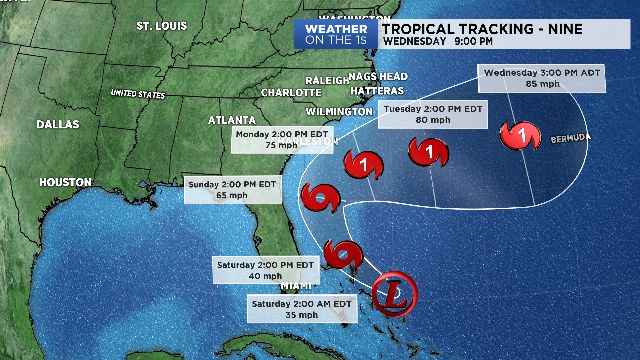
NORTH CAROLINA -- Potential Tropical Cyclone 9 is now officially Tropical Depression 9. It will likely be "Humberto" soon.
- The western edge of the forecast cone is now east of Florida and the Carolina's
- STAY INFORMED: Sign up for our breaking news and weather text alerts
- LISTEN TO OUR NEW PODCAST: Lt. Gov. Dan Forest Builds Political Career on Positive Ground
The forecast track has once again shifted to the east. In fact, the western edge of the forecast cone is now east of Florida and the Carolina's. That is a pretty significant change since Thursday.
If this verifies, impacts for our coast could be minimal with higher surf and rip currents for Monday, Tuesday, and Wednesday of next week. But understand, there will be more changes with this forecast.
Just a slight shift back to the west and our impacts become much more significant. Don't drop your guard on this one yet. Remember, you can get all the latest information 24 hours a day with your Weather On The One's Forecast on Spectrum News.