


Now that we’re getting closer to true lake effect season, I thought I would dispel the myth that a warmer than average lake equals more lake effect snow.
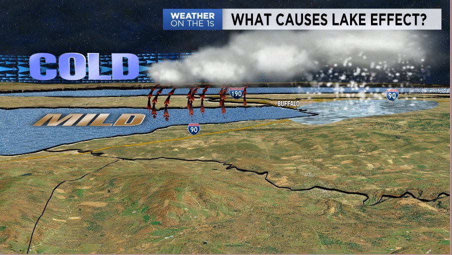
First, let’s get a basic understanding of how lake effect forms. To get any kind of active weather we need rising motion in the atmosphere. We get this in terms of lake effect when colder airmasses move over a much warmer body of water. The air at the surface is warmed by the warm water and rises into the colder air as warm air is more buoyant.
Typically, you need a 23-degree difference between the surface water temperatures and the air temperature at about 5000 feet. This will provide enough buoyancy for air to rise fast enough to create lake effect snow.
There are other ingredients needed as well, including how dry the air is, wind direction, and wind shear. For the purpose of this article, however, we’re going to focus on the temperature difference.
Water has much higher specific heat than air and that's why it holds its warmth as we enter the winter months. It also means it doesn't deviate from its typical or average temperature for that time of year.
For example, the average water temperature for Lake Erie on Nov. 16 is 49 degrees, while the record warm water temperature for that date is 53 degrees. That’s only a four-degree difference between the long term average and the record high.
If we look at Buffalo air temperature stats for that same date, the average high is 48 degrees and the record high is 69 degrees. That’s a 21-degree difference! In other words, a bigger difference in air temperature is more likely compared to surface water temperature.
Let’s take a look at 2014’s Snowvember. On Nov. 17, the start of the event, the surface water temperature for Lake Erie was 47 degrees. That was actually a degree below average. However, the air at about 5000 feet was only about 5 degrees. That whopping 42-degree difference was well over the needed 23-degree difference.
That huge gradient is what helped to create such large snowfall rates and the rest is history, even with the lake running a degree below average. It was more about the anomalous cold air than Lake Erie’s surface water temperature.
Last season, Lake Erie never got close to freezing over and surface water temperatures were running near to above average almost the entire season. We finished with under 70 inches of snow for the season, which was well below average by more than two feet.
The relatively warm waters of Lake Erie didn’t help out much when it came to lake effect snow. One of the main reasons why is that we never had enough deep cold air to produce the temperature difference needed for lake effect. December, January, and February all finished with above-average temperatures.
To sum up, while warmer-than-average surface water temperatures can help produce lake effect snow, the air temperature is a much bigger component. While surface water temps vary a few degrees between the average and records, our air temperature can vary as much as 20 to 30 degrees from the average. This means anomalous cold airmasses, especially early in the season when the lake is still holding quite a bit of warmth, are a much bigger factor.
As far as what we think for this season and if we’ll see these anomalous cold airmasses, stay tuned and be on the lookout for our annual winter weather forecast special that will air sometime in November. If you'd like, you can go back and see what we forecasted last year here.