


Monday brought heavy rain, strong winds and flooding to parts of North Carolina.
Brunswick County experienced the brunt of it, seeing up to 19 inches of rain in Southport and almost 18 inches in Bolivia. Bladen County also saw its fair share, with 7.2 inches of rain near Elizabethtown.
Here are the highest rainfall totals from the potential tropical cyclone, according to the National Weather Service:
- New Hanover County, Carolina Beach, 20.81 inches
- Brunswick County, Southport, 19.13 inches
- Brunswick County, Bolivia, 17.85 inches
- Brunswick County, Sunny Point, 15.42 inches
- Brunswick County, Southport, 14.96 inches
- Brunswick County, Green Swamp, 14.57 inches
- Brunswick County, Green Swamp, 9.8 inches
- Brunswick County, Holden Beach, 8.7 inches
- Brunswick County, Southport. 8.5 inches
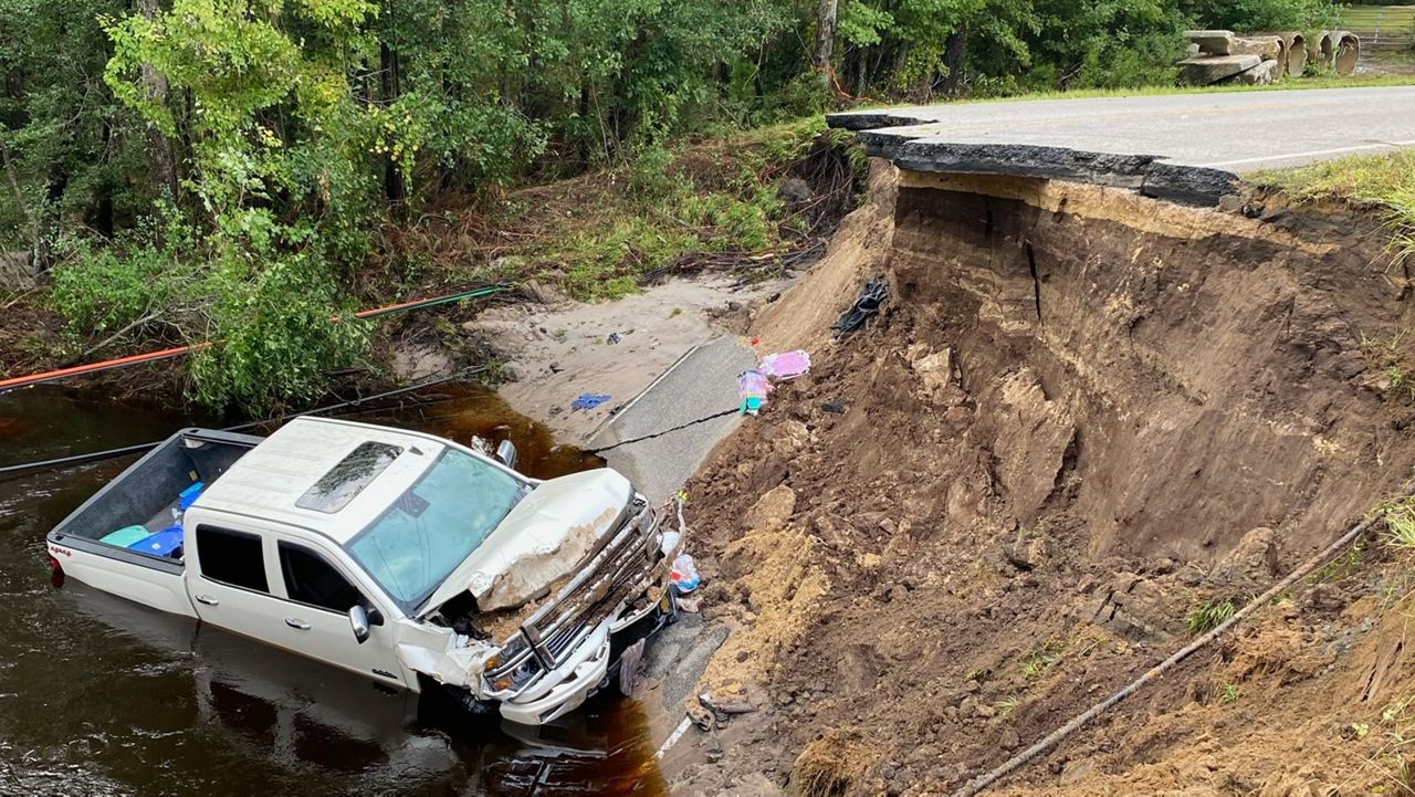
Rain washed out some roads in one part of the state and forced water rescues in others. State officials continued to urge caution.
The flash flooding closed dozens of roads in Brunswick County, including U.S. Highway 17, which is the main coastal route. Floodwaters swamped the highway at several points for most of the day, trapping some drivers on high ground that became an island.
Emergency workers brought food and water to people as they waited for the waters to recede, Brunswick County emergency officials said. No deaths were reported but dozens of roads in the county were damaged and many washed out.
Spectrum News 1 had teams on the ground providing coverage, while viewers sent in photos of what they were witnessing.
Several blocks of the coastal town of Carolina Beach were flooded to the bottom of car doors for hours Monday as the system, known as Potential Tropical Cyclone No. 8, never organized enough to become the eighth named tropical storm of the season, Helene.
It's not the first historic flood in the region by any measure.
Hurricane Diana in 1984 brought more than 18 inches of rain to the area and forecasters noted that it was the first time a tropical event had dropped a foot (30 centimeters) of rain to the area.
Since then, the area just southwest of Wilmington saw 20 inches of rain in Hurricane Floyd in 1999, which was once the benchmark for heavy rain.
An unnamed storm in the wake of Hurricane Matthew in 2010 dropped about 11 inches of rain on Brunswick County and a 2015 deluge as Hurricane Joaquin moved well offshore dropped 20 inches (51 centimeters) of rain.
And in 2018, Hurricane Florence brought what is now the touchstone for historic flooding across the region with 30 inches of rain.
The blame for recurring floods of a lifetime can be placed on rising temperatures because of climate change, said Tim Armstrong, a meteorologist with the National Weather Service in Wilmington.
“The warmer the air, the more moisture it can hold,” Armstrong said Tuesday.
As the three massive floods from unnamed storms show, it doesn't take a powerful hurricane, just the right combination of atmospheric factors to end up with big floods over small areas.
“The worst of Monday's flood was centered over just parts of two counties,” Armstrong said.
The rain from the system had moved into southeast Virginia on Tuesday. Along North Carolina's Outer Banks, the storm closed vulnerable coastal highway North Carolina 12 on Ocracoke Island and threatened several homes in Rodanthe, where erosion and rising sea levels have destroyed more than a half-dozen beachfront homes this decade.
The Atlantic hurricane season continues through the end of November.
In an updated hurricane outlook last month, the National Oceanic and Atmospheric Administration was still predicting a highly active season thanks to near-record sea surface temperatures and the possibility of La Nina. Emergency management officials have urged people to stay prepared.
Elsewhere in the Atlantic, Gordon remained a tropical depression as it swirled through open ocean waters. Gordon could either dissolve in upcoming days or strengthen back into a tropical storm, forecasters said.