Plenty of sunshine will be on tap for the remainder of the work week before a cold front moving through Saturday will bring rain back to the region over the second half of the weekend.
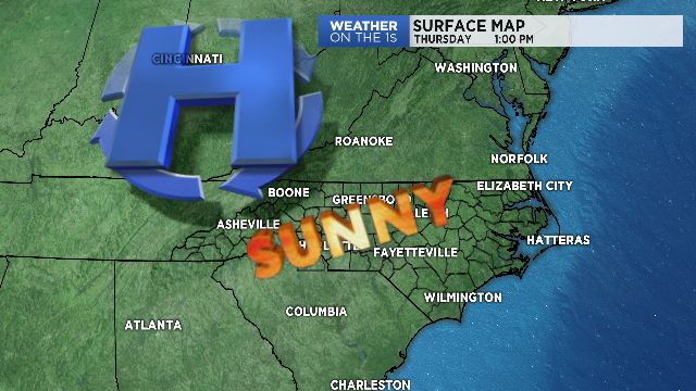
High pressure will remain across the southeastern United States through Friday, leading to dry and sunny conditions.
Thursday will be very similar to Wednesday with highs in the low to mid 50s and 40s in the mountains, where winds will diminish nicely through the day. Skies will remain clear Thursday night into Friday as temperatures begin to warm slightly into the weekend.
By Saturday, a cold front will begin moving through the Mississippi River Valley, with Gulf moisture streaming in ahead of it.
While Saturday will be dry during the day, expect increasing cloud cover into Saturday afternoon with highs warming into the upper 50s.
Rain will begin late Saturday night as the cold front begins moving in from the west Sunday morning, leading into what will be a rainy day Sunday. Rainfall totals will likely range from a couple of tenths of a inch to about a half-an-inch of rain.
This system will quickly scoot out of the area by early Monday, leaving us dry, yet again, to begin next week!
Get the latest news, sports and weather delivered straight to your inbox. Click here to sign up for email and text alerts.