


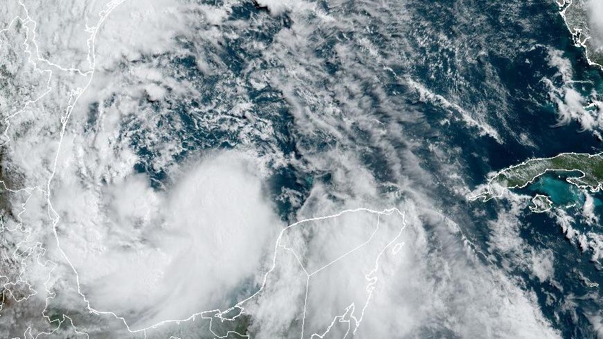
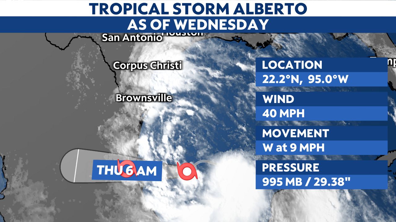
As of Wenesday morning, the broad area of low pressure formerly called Potential Tropical Cyclone One has now been named Tropical Storm Alberto by the National Hurricane Center (NHC).
What You Need To Know
- Alberto is located in the southwestern Gulf of Mexico and continues to intensify
- Tropical Storm warnings and Coastal Flood warnings are now in effect for areas of Texas
- Heavy rainfall is expected up and down the Texas coast with some areas getting more than 6" of rain
- Strong winds and isolated flooding is possible as far inland as the I-35 corridor
This system will likely continue to organize and strengthen as it nears the northern coast of Mexico and makes landfall around 6 a.m. Thursday.
Heavy rainfall, high surf and dangerous rip currents are likely as this storm moves just to the south of Texas. Tropical storm warnings now extend from Brownsville all along our Texas coastline through Beaumont.
This forecast will continue to evolve, but heavy rain, strong winds up to 48 mph and flash flooding are expected for South Texas through Friday.
Forecasters will closely monitor Alberto as he turns westward throughout the day and hurricane hunter reports will watch for signs of strengthening. Alberto is the first named storm on the 2024 Atlantic hurricane season list; one that is forecast to be a highly active season.

While the rain has already started, expect multiple days of disruptive weather, high surf and dangerous rip tides for our coastal cities.
Forecast guidance indicates this system will move west into Mexico’s Gulf coastline early Thursday then progress westward across Mexico.
Several days of significantly heavy rainfall is expected for Mexico with mudslides and flash flooding possible there. It is becoming increasingly likely that widespread rain, high surf, strong rip currents and strong winds will impact Texas due the the counterclockwise rotation of these systems and that the largest swath of moisture advances northward from the center of circulation.
The Weather Prediction Center (WPC) has already highlighted flash flooding concerns from Corpus Christi down the Padre Island National Seashore to Port Isabel and Brownville then west including Kingsville to Laredo. There is a moderate of 40% likelihood for seeing flash flooding in these towns.
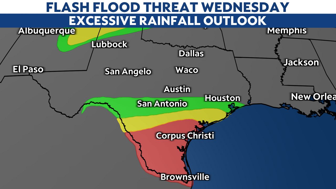
The threat for flooding will expand to include parts of the I-35 corridor through the end to the week.
Areas like Brownsville, Corpus Christi, Houston and Rio Grande Plains could see rainfall totals upwards of 6.5” by Friday. Even Austin and San Antonio could pick up more than 4" of total rainfall over the next two days.
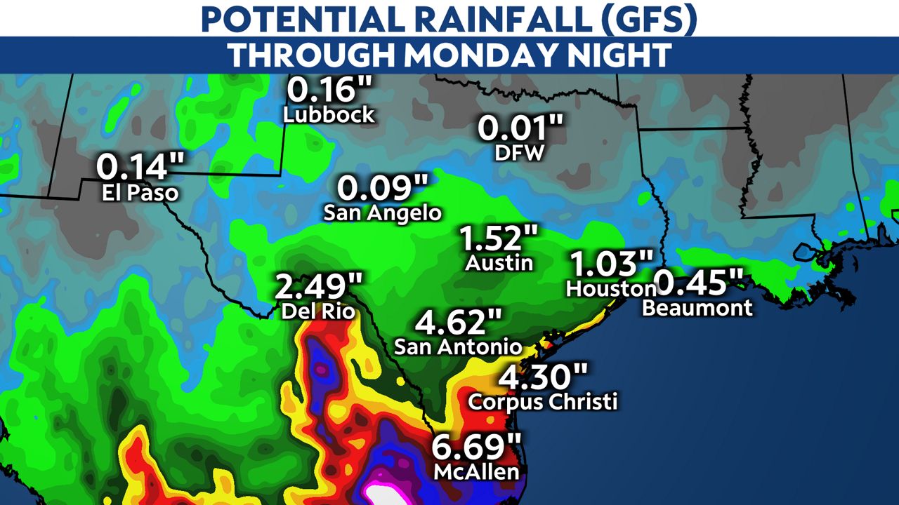
Rain coverage from Central Texas towards Dallas-Fort Worth will gradually diminish south to north. We are expecting less than a quarter inch of rain for North Texas, although some isolated areas to the south into Waco may pick up closer to an inch.
Our team of meteorologists dives deep into the science of weather and breaks down timely weather data and information. To view more weather and climate stories, check out our weather blogs section.