


Back on November 15-16, 2001, an extreme 14" of rain hit the metro Austin & San Antonio areas, causing creeks, streams, and rivers to rush out of their banks. As many as 10 people were reportedly killed in the Lone Star State by the two day storm.
Here's a storm summary provided by the U.S. Geological Survey:
"The storm of November 15, 2001, began with mild to moderate rainfall over the night of November 14th and through the morning of November 15. At about 3:30 p.m. on November 15th, a large thunderstorm cell began to approach the Hays-Travis County line, with tornadoes and intense rainfall. The tornadoes touched at various locations along the I-35 corridor starting near Buda and the Ben White Blvd. - I-35 interchange and continuing north and east through Travis County. The heaviest rainfall began about 3:30 p.m. over south-central Austin in the middle of the Slaughter Creek Basin and upper South Boggy Creek Basin. The intense thunderstorm cells continued to track rapidly and generally north-northeast over Barton Creek at Loop 360, West Bouldin Creek, Johnson Creek, and Shoal Creek. The area of the most intense rainfall decreased as it tracked farther north over the upper Little Walnut and Walnut Creek watersheds. Although the storm gradually decreased in intensity over the next 6 hours, it continued to produce intense rainfall.
Widespread rainfall totals typically ranged from 5 to 8 in., with individual reports of 10 in. and more. Much of this rain fell within about 6 hours. Generally, the storm intensities and flood levels were higher on the south and west sides of Austin. Rainfall intensities exceeded the estimated 100-year rainfall rates in some locations and caused widespread but isolated flood damage where the drainage capacity of streets and storm drains was exceeded by localized rainfall.
The flow measured in area creeks does not match the statistical significance of individual maximum rainfall measurements because the intense rainfall was not evenly distributed over all of the watersheds. For example, the USGS estimated that the flood peak in Onion Creek at U.S. Highway 183 was approximately 93,200 cubic feet per second, which corresponds to about a 50-year peak. Other watersheds on the south and west (for example, Slaughter, Williamson, South Boggy, West and East Bouldin, Barton, Bull, Johnson, and Shoal Creeks) experienced flood peaks that correspond to a return period of 5 to 20 years. The USGS gage on Shoal Creek at W. 12th Street recorded a peak corresponding to approximately a 10-year return period. Watersheds on the east side of town (for example, Waller, Boggy, Tannehill, Fort, and Buttermilk Creeks) were less affected and experienced flood peaks corresponding to return periods of less than 10 years. Other watersheds that flow from northwest to east (for example, Little Walnut and Walnut Creeks) experienced peaks corresponding to return periods of up to 10 years."
Damage: 968 homes were flooded and cost of damages to public property was $11.3 million."
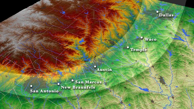
Flash flooding is the #1 storm-related killer in Texas. Austin is located in the heart of what we call "flash flood alley" that runs up and down the Blacones Escarpment, pretty much right along I-35 from San Antonio to Dallas.
Flash flooding can occur any month of the year, any time of the day or night, but is historically most likely in the spring and fall months.
With a total of 8.07" at the Austin metro (Camp Mabry) gauge, making it the wettest November in the city's history.
For more about the November 2001 flood event, check out this report from NOAA.
Back on November 15-16, 2001, an extreme 14" of rain hit the metro Austin & San Antonio areas, causing creeks, streams, and rivers to rush out of their banks. As many as 10 people were reportedly killed in the Lone Star State by the two day storm.
Here's a storm summary provided by the U.S. Geological Survey:
"The storm of November 15, 2001, began with mild to moderate rainfall over the night of November 14th and through the morning of November 15th. At about 3:30 p.m. on November 15th, a large thunderstorm cell began to approach the Hays-Travis County line, with tornadoes and intense rainfall. The tornadoes touched at various locations along the I-35 corridor starting near Buda and the Ben White Blvd. - I-35 interchange and continuing north and east through Travis County. The heaviest rainfall began about 3:30 p.m. over south-central Austin in the middle of the Slaughter Creek Basin and upper South Boggy Creek Basin. The intense thunderstorm cells continued to track rapidly and generally north-northeast over Barton Creek at Loop 360, West Bouldin Creek, Johnson Creek, and Shoal Creek. The area of the most intense rainfall decreased as it tracked farther north over the upper Little Walnut and Walnut Creek watersheds. Although the storm gradually decreased in intensity over the next 6 hours, it continued to produce intense rainfall.
Widespread rainfall totals typically ranged from 5 to 8 in., with individual reports of 10 in. and more. Much of this rain fell within about 6 hours. Generally, the storm intensities and flood levels were higher on the south and west sides of Austin. Rainfall intensities exceeded the estimated 100-year rainfall rates in some locations and caused widespread but isolated flood damage where the drainage capacity of streets and storm drains was exceeded by localized rainfall.
The flow measured in area creeks does not match the statistical significance of individual maximum rainfall measurements because the intense rainfall was not evenly distributed over all of the watersheds. For example, the USGS estimated that the flood peak in Onion Creek at U.S. Highway 183 was approximately 93,200 cubic feet per second, which corresponds to about a 50-year peak. Other watersheds on the south and west (for example, Slaughter, Williamson, South Boggy, West and East Bouldin, Barton, Bull, Johnson, and Shoal Creeks) experienced flood peaks that correspond to a return period of 5 to 20 years. The USGS gage on Shoal Creek at W. 12th Street recorded a peak corresponding to approximately a 10-year return period. Watersheds on the east side of town (for example, Waller, Boggy, Tannehill, Fort, and Buttermilk Creeks) were less affected and experienced flood peaks corresponding to return periods of less than 10 years. Other watersheds that flow from northwest to east (for example, Little Walnut and Walnut Creeks) experienced peaks corresponding to return periods of up to 10 years."
Damage: 968 homes were flooded and cost of damages to public property was $11.3 million."
Flash flooding is the #1 storm-related killer in Texas. Austin is located in the heart of what we call "flash flood alley" that runs up and down the Blacones Escarpment, pretty much right along I-35 from San Antonio to Dallas.
Flash flooding can occur any month of the year, any time of the day or night, but is historically most likely in the spring and fall months.
With a total of 8.07" at the Austin metro (Camp Mabry) gauge, making it the wettest November in the city's history.
For more about the November 2001 flood event, check out this report from NOAA.