Despite what the nation thinks of when they hear Buffalo, N.Y., it does not snow every day, especially not in October.
A lot of the time, we have, what meteorologist Dan Russell likes to call, bonus summer warmth! However, that was not the case in October of 2006.
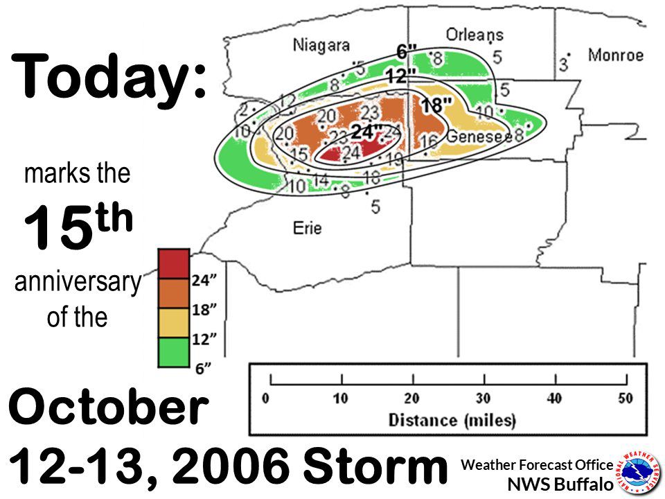
Fifteen years ago, a lake-effect storm rolled through the area on the 12-13th, dumping 22.6 inches of heavy wet snow on the Buffalo Niagara International Airport.
The October storm had a lot of components that made it devastating to Western New York.
The first troubling piece of this event was all of the leaves on the trees. Because it was so early in the fall season, Buffalonians were still enjoying the peak fall foliage.
When lake-effect snow started to fall that day, it was heavy and wet, and it added a lot of weight to tree limbs. When the snow kept stacking up and showed no signs of stopping, tree limbs started to come down.
A lot of them, unfortunately, fell on power lines and onto roads. This made the loss of power inevitable for a lot of people. The blocked roads also didn't allow for power companies to get to places quickly.
Now back to the lake-effect snow. Typically, meteorologists use a 10:1 ratio to forecast snow. That equates to every 1 inch of water equals 10 inches of snow.
During the October storm, snow to liquid ratios were 6:1. That means the snow was heavy and wet! It weighed a lot more than the average fluffy, light snow, creating serious problem number two.
Here is a look at how the snow stacked up all around Western New York:
The lake-effect band did not move around a lot and lasted for an extended period. Lake Erie was 62 degrees (above average for the date) and provided a lot of fuel to allow this storm to keep producing snow.
And another indicator of just how heavy the snow was, was the almost nonstop thunder and lightning throughout the event!

I've been forecasting for Western New York television stations for eight years now. Viewers from all around the area always bring up this storm to me.
People share their stories of cleanup efforts, of what they did to pass the time without power, about what they ate and how they took care of themselves. My story is a little different.
I was a freshman in high school and waiting to go to a homecoming dance on Saturday the 14th. I was so excited about my first school dance.
My mom lived in Cheektowaga at the time, and I lived in Pendleton. We had planned a nice mother-daughter day to get me ready for the dance, and I left my dress at her house. But because of the storm, my mom could not bring it to me!
As a 15-year-old, I did not care that the whole city was under a state of emergency. All I cared about was that dress getting to me! This story proves that even your smiling meteorologist was a brat growing up.

After giving my mom a lot of attitude, the school ended up postponing the dance, and all was well again in my mind. Unfortunately for many people, including my mom, the city did not restore power until almost two weeks later!
This storm wreaked havoc across the board. 22.6 inches is the highest 24-hour snowfall accumulation in October. In addition, it was the 6th greatest snowfall EVER reported in Buffalo. For information on the storm through the National Weather Service in Buffalo's eyes, click here.
I want to hear your story of the October storm! Please share with me on my social media accounts: Meteorologist Kaylee Wendt on Facebook, Instagram and Twitter!


