


)
December 2010 was a snowy one for North Carolina.
Several different winter systems impacted the state, but the biggest snowstorm came at the end of the month, just in time to give part of North Carolina a white Christmas, and all of the state snow on the day after Christmas.
Overall, the odds of snow on the ground on Christmas Day are pretty low for most locations in North Carolina. The chance of a white Christmas are about 1 percent for most areas.
That chance is higher in the mountains of the state where at the higher elevations, the chance of a snow for Christmas is roughly 5 to 25 percent, depending on the elevation.
So as you can see, a Christmas winter storm is pretty rare east of the mountains.
What was interesting about this event is that it showed up in the weather models many days before the first snowflake fell.
Climatologically speaking, many of us thought that the models were "hasing a phantom storm – that is, a system that really should not happen this time of year but still shows up on the models and normally doesn't amount to anything.
But this system was different. Model run after model run, the system was there giving North Carolina snow for Christmas.
A few days before Christmas, it was clear there would be snow in North Carolina sometime from December 24 through December 26. The only questions that remained were where exactly, when would the snow begin to fall, and how much snow would fall.
Snow began to fall early Christmas morning in the western parts of North Carolina. The mountains picked up a range of 4 to 12 inches of snow.
By late morning, snow began to fall across the Triad with a Christmas day total of 4 to 7 inches of accumulation.
.jpg)
By late evening on Christmas, low pressure was strengthening off the Southeast coast. In parts of the northern Triangle, some light accumulation was reported just before midnight, but the majority of the snow fell after midnight and into the next day.
As the winter storm grew stronger, it pulled more moisture in from the Atlantic Ocean and more cold air in from the north. The combination set the stage for snow across the state from that night and well into the day on December 26.
By the morning of the 26th, most of North Carolina was covered with multiple inches of snow.
.jpg)
.jpg)
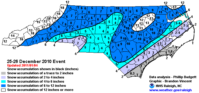
When all was said and done, and the final snowflakes had hit the ground, most locations in North Carolina has seen at least five inches of snow. Some had seen a lot more.
The storm produced up to a foot of snow accumulation along the northern I-95 corridor. When the snow from the event was totaled, all of North Carolina had seen at least some snow.
The overall totals ranged from a trace of snow for parts of the Outer Banks and the coast, to almost two feet at Mount Mitchell.
So as the Christmas snowstorm of 2010 has shown us, if you're "Dreaming of a White Christmas," it is possible... even in a southern state like North Carolina.