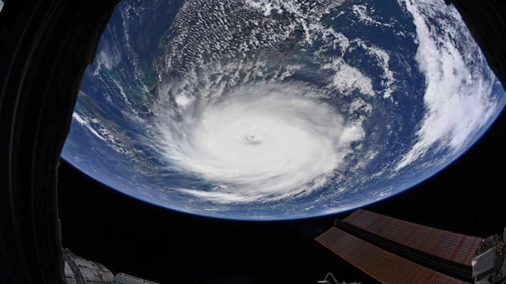
ORLANDO, Fla. — Dorian is still sitting on Grand Bahama Island, battering it as the Category 3 hurricane has winds of 120 mph.
- DORIAN LATEST:
- TRACK IT: Get tropical updates, forecast models, satellite loops, and more
- POWER OUTAGES: Interactive maps and phone numbers
- CLOSURES: School, business, facility closures
- SAND BAGS: Where to find sand bags in Central Florida
- Central Florida blood bank OneBlood needs donations
- STORM SEASON 2019 RESOURCES:
- GET WEATHER ALERTS: Sign up to receive weather text alerts from Spectrum News 13
- FREE WIFI HOTSPOTS: Charter Communications has opened up more than 32,000 Spectrum WiFi hotspots in Florida, making them available to all to help in preparation for Hurricane Dorian. Visit this link at Spectrum.com for more information on the exact location of those Spectrum Hotspots in Spectrum service areas across Florida. To connect, look for the Spectrum WiFi Network under your device’s WiFi settings. Charter Communications is the parent company of Spectrum News 13.
Hurricane Dorian's winds have fallen to 120 mph, with a barometric pressure up to 950mb.
The latest positioning had Dorian located 105 miles east of West Palm Beach. Dorian’s wind field remains the same, with hurricane force winds extending out 45 miles from the center, while tropical storm force winds extend out about 160 miles.
Watches and warnings in effect:
A storm surge warning is in effect for:
- Lantana to Altamaha Sound
A storm surge watch is in effect for:
- North of Deerfield Beach to south of Lantana
- Altamaha Sound to South Santee River
A hurricane warning is in effect for:
- Grand Bahama and the Abacos Islands in the northwestern Bahamas
- Jupiter Inlet to Ponte Vedra Beach
A hurricane watch is in effect for:
- North of Deerfield Beach to Jupiter Inlet
- North of Ponte Vedra Beach to South Santee River
A tropical storm warning is in effect for:
- North of Deerfield Beach to Jupiter Inlet
- Inland Volusia, Lake, Seminole, Orange, Osceola, and Polk County
- North of Ponte Vedra Beach, FL to Savannah River
A tropical storm watch is in effect for:
- North of Golden Beach to Deerfield Beach
- Lake Okeechobee

A slow northwestward motion is forecast for early Tuesday, followed by a gradual turn toward the north late Tuesday.
Dorian will move dangerously close to the Florida east coast Tuesday through Wednesday evening.
The northerly turn is key, especially the timing of this turn. We could see it now starting later Tuesday morning, which keeps the eye off-shore.
Increasing swell will be found along the Florida east coast and the southeastern United States coast during the next few days.
These ocean conditions are likely to cause life-threatening surf and rip current conditions.

Flooding could become a concern for parts of Florida's East Coast. Rainfall totals of 2 to 6 inches will be possible in Florida, especially along/east of Interstate 95, with higher amounts not out of the question.
Dangerous seas, including life-threatening surf and storm surge, will accompany the storm.
It is important to know the exact impacts will depend on exactly when the turn to the north occurs. A few tornadoes will be possible in some of the squalls that come ashore.
Hurricane Watches, Tropical Storm Watches for Florida


With it being the height of hurricane season, we encourage Central Florida residents to stay with us for updates, and review your hurricane plans and kits.