


Mostly cloudy skies along with the chance for showers are in our forecast everyday for the rest of this week. That chance for rain could be enhanced around the end of this week all thanks to Tropical Storm Joaquin.
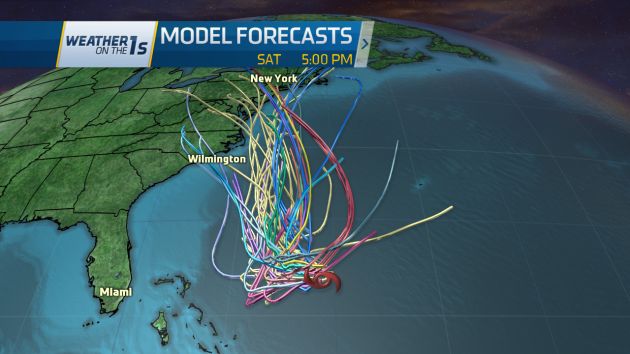
The track of the storm and exactly how it may impact the state does remain a bit uncertain. Most computer model forecasts from Tuesday morning (shown above) keep the storm just off the Carolina coast. However, we will have to watch a front that will stall off the North Carolina coast Thursday.

This front will likely hang around near the coast or just offshore through the end of the week. Moisture from Joaquin may get pulled along the front ahead of the storm. That would bring heavy rain to at least eastern North Carolina Friday and possibly into early Saturday. Some models show a frontal position that would bring some of the heavy rain from from near the coast into central North Carolina as well.
Early rainfall estimates from computer models vary greatly at this point.
One model (GFS) shows the heaviest rain confined near the coast and from north eastern North Carolina into portions of Virginia.

Another model (the Eurpoean) shows some of the heavier rain moving from the coast inland to portions of the Triangle and Sandhills.

Heavy rainfall could bring a flooding threat to parts of the state. Accurately pinpointing what areas will see the heaviest rain and how much is next to impossible at this point. Breezy conditions are also likely. With a saturated ground, downed trees are possible.
The forecast for Joaquin and how it may or may not impact the state should become clearer over the coming days. Stay tuned to Weather on the 1s on Time Warner Cable News for the latest updates.
More weather resources from twcnews.com: