

A University of Hawaii at Manoa geography professor used new mapping techniques to create a map that reveals the trees on Maui are taller than previously thought, according to a news release.
Qi Chen employed remote sensing technology (airborne lidar) as reference data to train models based on satellite imagery, creating a more accurate mapping tool. Researchers analyzed the colors and values of each pixel in satellite and lidar imagery to deduce the height of trees.
“The revised height estimates for Maui’s forests have significant implications, influencing factors such as water yield, carbon sequestration and wildlife habitat suitability,” said Chen.
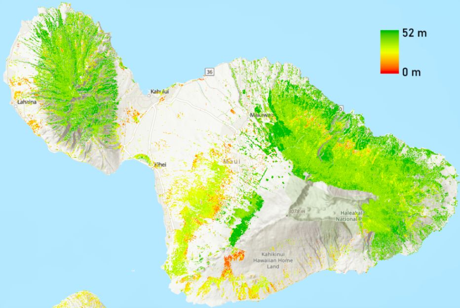
While mapping the horizontal spread of forests is simple, determining the vertical height of forests has been challenging. Mapping the height of forests provides valuable information.
For example, taller trees may increase the risk of certain types of fires and forests with a wide range of tree heights support more biodiversity. Researchers also use tree height to calculate carbon sequestration rates.
“The revised height estimates for Maui forests will help enhance the accuracy of calculations for factors like evapotranspiration, wind speed, and carbon sequestration rates, aiding in the development of more precise ecological models and decision-making processes,” said Chen. “It will also provide critical information needed to accurately evaluate the upstream freshwater yield, a crucial consideration for town planning in watersheds like Lahaina.”
In 2021, researchers developed a similar tree map for Oahu. The research team plans to expand its efforts and create maps for Kauai in 2024 and Hawaii Island in 2025.
The U.S. Geological Survey, through AmericaView, has provided $119,500 in funding since 2019 for the mapping project, with $23,500 allocated to the Maui Forest Height Map.