
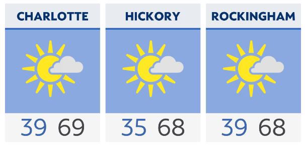
Some areas of patchy frost will be possible under a clear sky and lighter winds early Sunday morning west and northwest of the Charlotte zone. The Asheville region has a freeze warning for Sunday morning. Spring vegetation should be protected.
A substantial warmup occurs Monday, ahead of the next cold front, with highs topping out in the 80s for much of the region. A few showers are possible as the front moves in early Tuesday, but the best chance for any measurable rainfall will stay confined to the Tennessee border.
As the front exits, a cool and dry air mass settles back in. There will likely be another front forced southward near the end of the week, but this will not bring any precipitation.
Check radar and the latest 7-day forecast | Share your weather photos