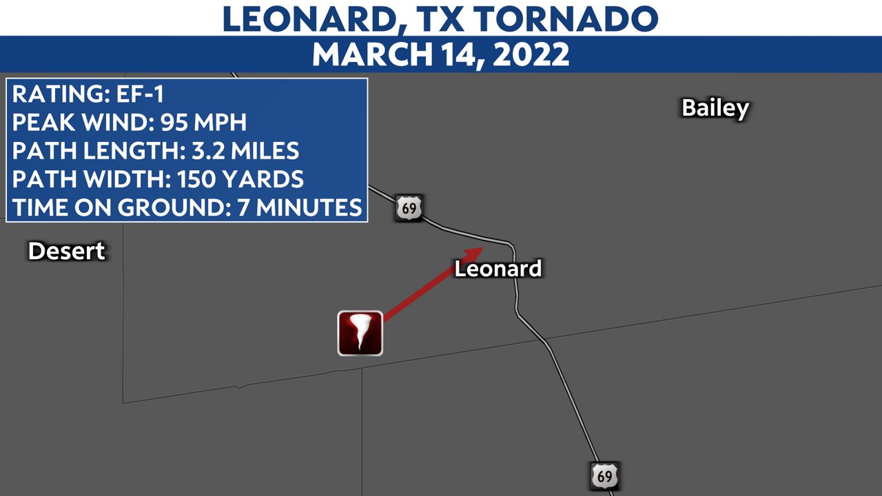
The tornado that hit Leonard, Texas on March 14 wasn't on the ground for long. For seven minutes, a supercell thunderstorm produced a tornado that damaged a metal barn, broke windows and destroyed the roof of a single-family home.
Watch aerial footage of the damage in the video player above.
This was the first twister of the spring season in North Texas, but as tornado climatology tells us, this is not the last.
What You Need To Know
- Fannin County tornado ruled an EF-1 with peak winds of 95 mph
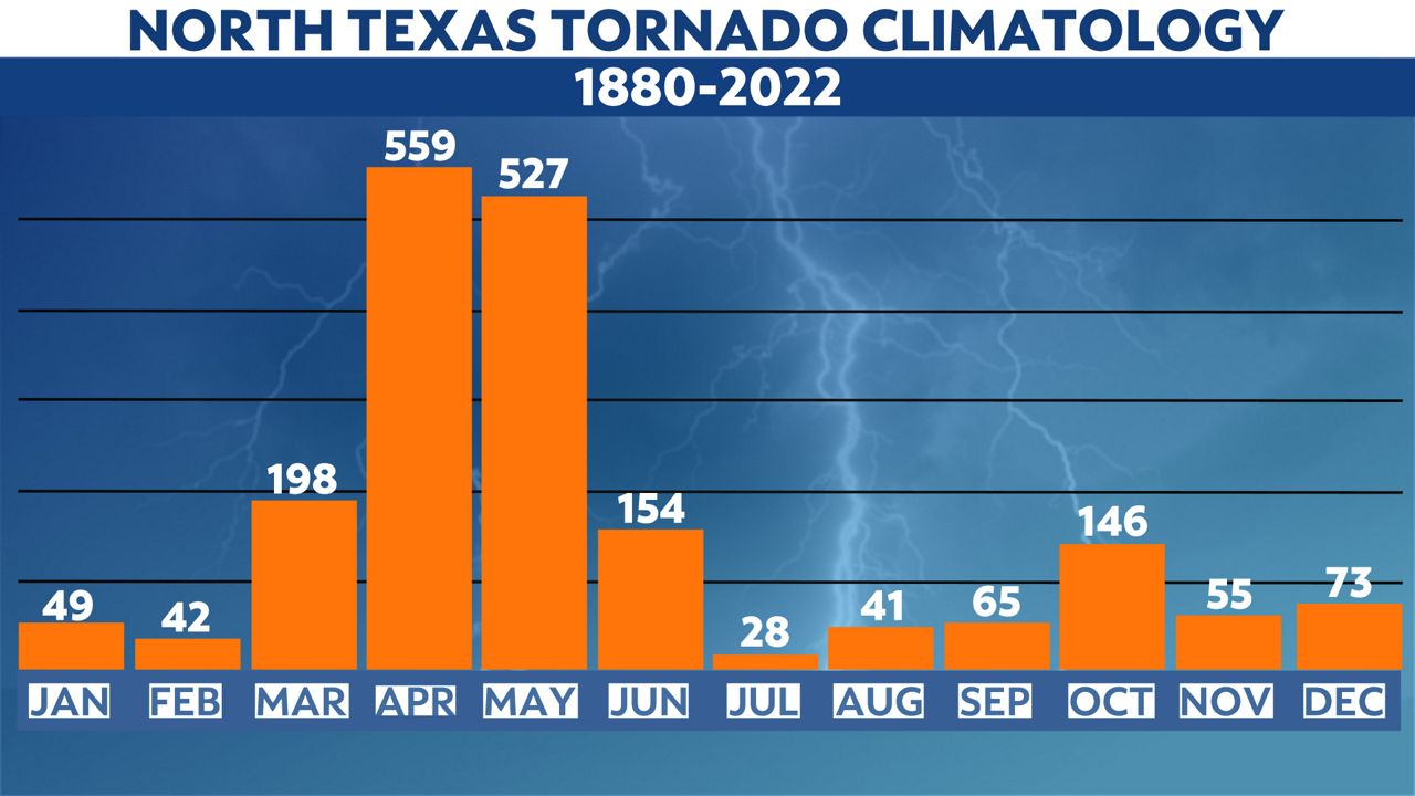
- North Texas has witnessed 198 tornadoes in the month of March since 1880
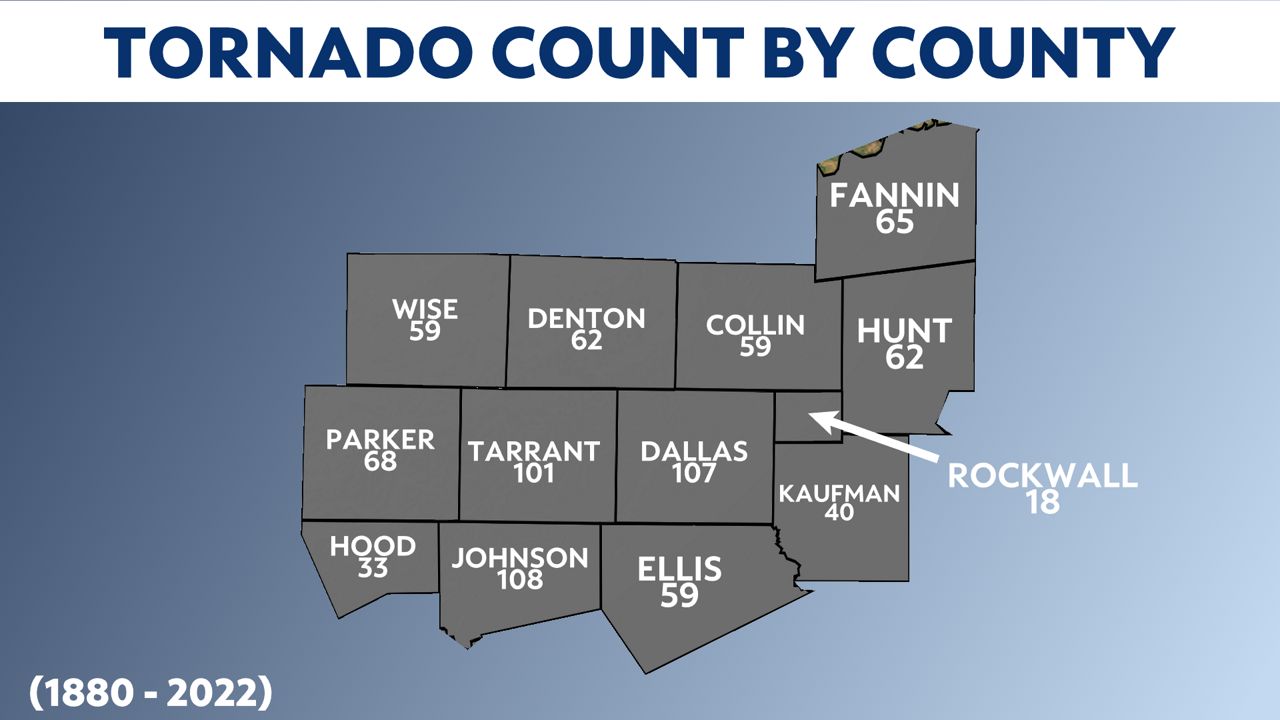
- Three core counties in North Texas have see the most tornadoes to date
- There are more than 4.9 million Texans that live in the heart of North Texas
Fannin County, Texas
The tornado began south of State Highway 78, damaging trees and a metal barn. The tornado moved north and east, leaving damage in its path before lifting back into the sky just shy of U.S. Highway 69.

The National Weather Service ruled it an EF-1 tornado with winds peaking at 95 mph.
North Texas tornadoes by the numbers
While fewer than 2,000 people live in Leonard, according to the 2020 U.S. Census Bureau, more than 35,660 Texans who call Fannin County home. Since 1880, 64 tornadoes have ripped through this part of the state. Monday's twister makes 65.
However, the number of tornadoes that have touched down in the Dallas/Fort Worth metro are much greater and so is the number of people living there.

From 1880 to present day, 1,284 tornadoes have impacted North Texas during meteorological spring: March, April and May. What's troubling is that the largest number of tornadoes recorded in any given month occur in three very populated counties: Dallas, Tarrant and Johnson.

In 2020, it's estimated that more than 4.9 million Texans live in these counties. That's 16.9 percent of the total Texas population.
Why is 'tornadogenesis' always occurring in North Texas?
Tornadogenesis is the process in which a tornado forms. While tornadoes can happen any time of the year in North Texas, the early spring and the early fall are our two main severe weather seasons.
Part of the reason has to do with two competing air masses. The first is the warm, moisture-rich air mass from the Gulf of Mexico. The second is the dry air mass from West Texas.
In favorable severe weather setups, that dryline out west mixes east and acts like a cold front, initiating storms that can quickly turn dangerous as they advance to the east.
Stay prepared
The best way to stay ahead of storms is with up-to-date weather forecasts before severe weather threatens your home. Download the free Spectrum News app and watch the radar right from your phone. Make sure you have severe weather notifications turned on.


