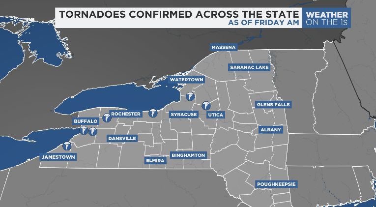
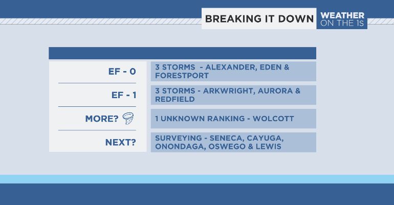
Wednesday was an active day across all of New York state. There were around 200 local storm reports issued across the state and 42 separate tornado warnings issued. As of Friday morning, seven tornadoes have been confirmed.
Tornado warnings in New York started popping up just before noon on Wednesday, July 10, 2024. A day that will go down in history as one of the most active tornado days ever recorded in Western New York, if not the state. The Buffalo National Weather Service office says they issued 18 tornado warnings, which is the most warnings they've ever issued in a single year, let alone day! Many of those warnings verified as storm spotters and radar confirmed multiple tornado touchdowns.

The first confirmed tornado began in the town of Arkwright, located in Chautauqua County. That storm ended up being an EF-1 tornado meaning winds reached at least 110 mph. The tornado stayed on the ground for three miles before lifting off the ground, ending in the town of Hanover. Within the path of destruction, many tress were damaged and toppled over. There was substantial damage to roofs throughout the area in addition to structures of homes and barns blown out.
The second confirmed tornado was in the town of Eden, located several miles south of Buffalo in Erie County. This tornado ended up being an EF-0 tornado, with maximum winds reaching 85 mph. It was on the ground for just under a mile but left a lot of destruction in its wake. Eden is a farming community, so damage to many barns was seen, a few animals were injured and lots of trees and crops were left disheveled.
A third tornado, in the town of Alexander located near Darien Lake Theme Park, was observed just before 1:45 PM. There, enough damage was on the premise to rank it an EF-0 storm. Trees were snapped in half in addition to seeing other minor damage to nearby homes and barns. This storm was on the ground for just 1 mile before dissipating.
The fourth confirmed tornado began in the town of Aurora, located in Erie County. After survey, the storm was determined to be an EF-1 tornado meaning winds reached at least 110 mph. The tornado stayed on the ground for 1.5 miles before lifting off the ground, ending further into the town of Aurora. Within the path of destruction, many tress were uprooted and damaged. In addition, a new horse barn was struck ripping off the roof and blowing out most of the windows. Despite all of the damage, thankfully there were no fatalities or injuries reported.
The fifth confirmed tornado was in the town of Wolcott, in Wayne County, an EF-Unknown tornado was confirmed. This tornado was very brief, 0.1 miles long, and caused no damage. Eyewitness's reported seeing a tornado lifting a vehicle off of the road.
The sixth confirme tornado came from Oswego County, in the town of Redfield. The National Weather Service in Buffalo concluded this tornado to be an EF-1 with peak wind of 90 mph and 2.2 miles long. Tree damage is the only known damage at this time.
The seventh confirmed tornado from the day happened in Oneida County, Forestport. An EF-0 tornado has been confirmed by the National Weather Service in Binghamton. The estimated peak wind of the storm was 80 mph. It was on the ground for 0.6 miles, and produced a width of 75 yard.
Believe it or not, more tornadoes are expected to be confirmed as surveying continues Friday. Areas of focus for those surverys include Seneca, Cayuga, Onondaga, Lewis and Oswego counties.

Our team of meteorologists will provide updates to you both on-air and online as more storms get confirmation.


