Typically, snow creates a quiet winter scene, but sometimes it can be interrupted by a muffled crack of thunder.
Snow is a common occurrence here in New York State, but thundersnow is much more rare.
The process itself is very similar to how thunder and lightning are created in a typical thunderstorm. Both require a combination of moisture, instability, and a lifting mechanism.
Going back to the basics, thunderstorms form when warm air at the surface rises upwards. That’s because warm air is less dense than cold air.
Which would explain why thunderstorm development is more common during the warmer months of spring and summer.
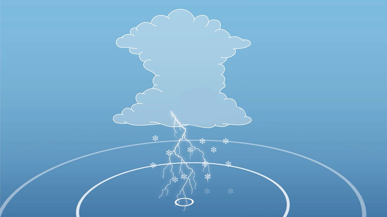
When warm air rises to a point that is below freezing, a process called triboelectrification begins. Triboelectrification is a charge of electricity that’s generated by friction created by colliding particles.
With thunderstorms, some particles that contact or slide against each other to create that friction are ice crystals.
When ice crystals collide with one another, that creates a separation in positive and negative charges. Those collisions then create static charges, and if enough of that builds up, lightning happens.
That process is more difficult to come to fruition during the winter simply because it’s cold, and that cold dense air will not rise. That’s where a lifting mechanism becomes important, such as a strong arctic cold front when it comes to intense snow squalls.
For example, if even colder air gets sucked in from the north, it’ll fall down because it’s even denser than the air at the surface. That pushes the surface air over the top of it.
But what about when it comes to thundersnow within bands of lake-effect?
When it comes to Lake Erie, it’s the shallowest of the Great Lakes, allowing it to heat more quickly during the summer. That warmth will slowly wane as fall turns to winter, but there can still be quite a difference in temperature between the water and the surrounding air.
As frigid air moves over the warmer waters of the lake, that warmth and moisture gets transferred to the lowest portion of the atmosphere. The air then becomes warmer and less dense than the overriding cold air, so it rises and creates lift.
Lift is a strong upward motion and because of this vertical motion, ice crystals and snowflakes can clash into each other, causing a static charge.
Shallow layers of unstable air can lead to even more upward motion, which increases snow growth and the chance of enough electric charge separation creating lightning.
Typically, it only produces flashes of lightning within the clouds. But the muffling effect that snow naturally creates can also make it tough to hear the thunder.
Since there’s more to overcome during the winter than with your typical summer thunderstorm, that’s why thundersnow usually only happens in an intense snowstorm that’s already producing heavy snow.
Our team of meteorologists dives deep into the science of weather and breaks down timely weather data and information. To view more weather and climate stories, check out our weather blogs section.
)