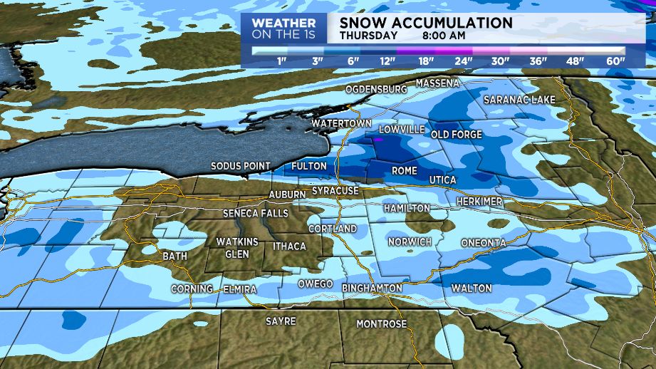
The more numerous scattered snow showers and passing squalls will tend to wind down overnight as we transition into localized heavy lake effect snow off of Lake Ontario. Initially, the heavier lake snows will be focused east/northeast of the lake (Jefferson, Lewis & Northern Herkimer Counties) but then settle a little farther south (pushing through Oswego, Oneida, Northern Cayuga, Southern Herkimer and even extreme Northern Onondaga & Northern Madison Counties for a time). The heavy falling snow will be paired with blowing and drifting snow; making for snow covered roads, reduced visibility and tough travel at times over parts of the aforementioned counties. Within the most persistent lake effect, 6 to 12+ inches of new snow is expected tonight.
Fortunately, lingering lake effect will taper tomorrow and after starting out with temperatures in the 10s and 20s, we'll recover into the 20s and 30s/near 40 degrees during the afternoon.
A push of milder air will come out ahead of a cold front on Friday as temperatures climb into the 40s; however, this is going to be accompanied by passing scattered rain/snow showers. Getting on the back side of this cold front this weekend, colder conditions look to return with highs in the 20s and 30s.