
NORTH CAROLINA — Hurricane Dorian made landfall Friday morning as it just brushed the Outer Banks and was followed by air evacuations, flooded streets, downed trees and power outages in the ensuing hours.
- DORIAN LATEST:
- LIVE UPDATES: Spectrum News Meteorologists, Reporters Track Dorian
- LIVE RADAR: Interactive NC radar from Spectrum News
- POWER OUTAGES: Duke Energy map, contact information for area companies
- CURFEWS: Updated list of curfews in NC
- PHOTOS: Severe weather pictures from Hurricane Dorian
- SHELTERS: List of NC shelters open for Dorian
- STORM SEASON 2019: Printable supply checklist, what you need to do before and after the storm, how to stretch your phone's battery life and more
- LISTEN: Is N.C. Ready for Another Hurricane? Lessons Learned from Florence
- GET UP-TO-THE-MINUTE WEATHER ALERTS: Sign up for Spectrum News text alerts for the latest on Dorian for your area:
8 p.m. Friday update:
Hurricane Dorian maintaned sustained winds of 90 mph and was moving northeast at 24 mph.
On the forecast track, the center of Dorian should move move to the southeast of extreme southeastern New England tonight
and Saturday morning, and then across Nova Scotia late Saturday or Saturday night.
Some strengthening is possible during the next 24 hours.
6 p.m. Friday update:
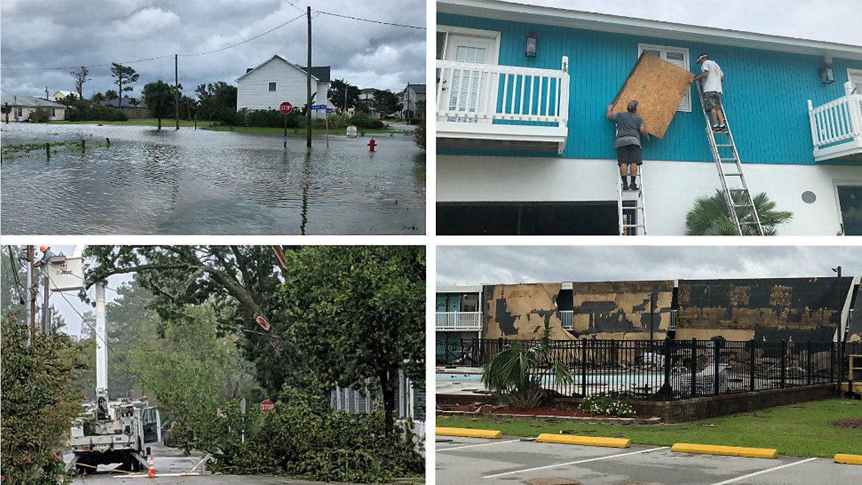
Spectrum News reporter Evan Sery has learned from NOAA that the agency is "very certain" a tornado tore through parts of Wilson Thursday night.
At one home, a tree was uprooted and another snapped and fell on a vehicle.
Meanwhile, in Emerald Isle, sections of roadway near the Boardwalk RV Park will remain closed as crews secure tornado related debris. Contractors are scheduled to begin debris removal, from the public right of way only, on Monday.
There were still downed cable and phone lines in some areas of Atlantic Beach, although the town curfew has been lifted. The city deployed stormwater pumps throughout town and many of its streets.
In Dare County, a mandatory evacuation remained in place. Those there should be aware of hazards including loose or dangling power lines. Motorists are advised to proceed with extreme caution, as standing water and sand may be on roadways.
5 p.m. Friday update:
All Hurricane and Tropical Storm Warnings are discontinued south of the North Carolina/Virginia Border, however Dorian mantains maximum sustained winds of 90 mph as it continues moving northeast.
A few minutes before 5 p.m., officials spoke about recovery efforts.
There were nearly 70 secondary roads impassable in the Outer Banks, which was hit particularly hard by Dorian.
More than 500 National Guard soldiers have been mobilized. There no deaths or serious injuries reported.
Ferry operations may resume as early 8 a.m. Saturday, but state officials say it could happen later.
Some strengthening is possible for Dorian during the next 24 hours. After that time, it is forecast to become a post-tropical
cyclone with hurricane-force winds Saturday night or Sunday while it is near or over eastern Canada.
4:30 p.m. Friday update:
Kill Devil Hills Police, Fire and Ocean Rescue responded to a call for a vehicle being swept into the ocean and the driver trapped in the vehicle.
A call came to 911 at approximately 2:30 p.m. concerning a white pickup truck that had gone in the ocean at Arch Street in Kill Devil Hills. The passenger was able to get out, however the driver was still in the vehicle. Officers arrived on scene and were able to get the driver out of the pickup.
The driver was identified as Troy J. Topash, 41, of Kill Devil Hills. Upon further investigation, Topash was determined to be impaired and was arrested, police said.
Kill Devil Hills Ocean Rescue was able to secure the pickup with a tow strap to prevent it from washing further out. Seto’s towing was eventually able to extract the truck from the ocean.
At the time of this incident, Kill Devil Hills was still under curfew because of Hurricane Dorian.
2:55 p.m. Friday update:
Air evacuations are taking place off Ocracoke Island.
"Due to the conditions on Ocracoke Island, we are dispatching air transportation units to help evacuate residents that need to leave," Hyde County officials said Friday afternoon.
The air units will take residents to Dare County, where there's a shelter. Priority is being given to seniors, anyone with medical needs, or those who have other special circumstances.
As soon as possible, the evacuation will continue via ferry, Hyde County officials said.
Call the Hyde County Emergency Operations Center at 252-926-3715 if you need to go.
The Ocracoke Mobile Veterinarian is coordinating pet rescues for those who need to evacuate but don't know what to do with their pets. If you'd like to help foster a pet or can offer boarding space, text them at 252-921-0087.
2 p.m. Friday update:
Hurricane Dorian is a Category 1 hurricane and 125 miles northeast of Cape Hatteras.
Over the past two hours, several National Weather Service stations on the Outer Banks reported 70-80 mph sustained winds as Dorian continues its trek northeastward, though winds are now decreasing, forecasters say.
Hurricane-force winds extend about 75 miles out from the eye, and tropical storm-force winds extend up to 220 miles out.
During the next few hours, Dorian will move away from the North Carolina coast.
11 a.m. Friday update:
The eye of Hurricane Dorian is moving east of the North Carolina coast over the Atlantic. By 11 a.m., the storm was located about 50 miles northeast of Cape Hatteras and roughly 460 miles southwest of Nantucket, Massachusetts. It is moving at 17 mph.
10 a.m. Friday update:
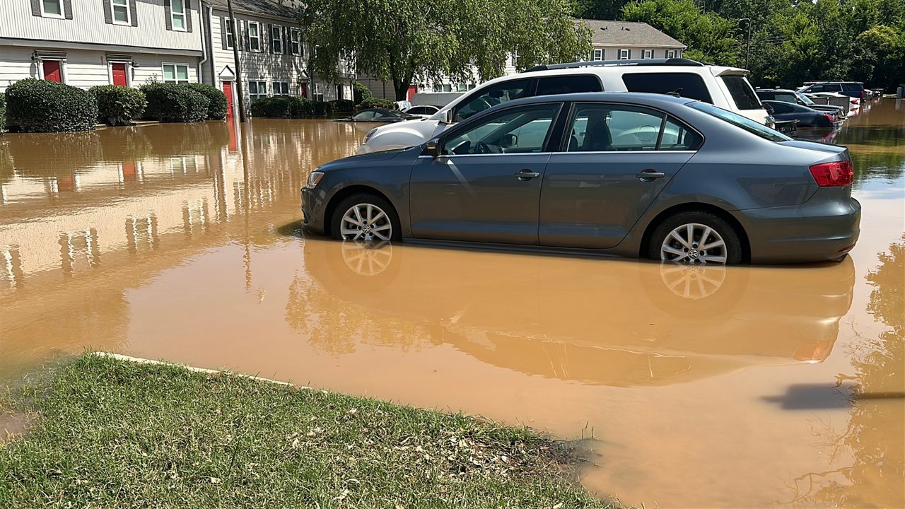
During a press conference Friday morning, Gov. Roy Cooper stated that Hurricane Dorian continues to batter the Outer Banks, and there is fear that people on Ocracoke Island could become stranded. Storm surge, Cooper said, continues to be the chief concern. Ocracoke Island, a thin strip of land, has seen a great deal of flooding, forcing some to climb into attics in order to avoid high water.
Cooper urged people to continue to heed evacuation orders and only return home when it is deemed safe to do so by officials.
He further said there are still roughly 215,000 power outages statewide. During the conference, a state emergency forecaster said it's estimated the storm produced about a dozen tornadoes in North Carolina.
We're getting some pictures and videos of the severe flooding due to storm surge on the Outer Banks. This is Ocracoke, NC. Our hearts go out to ALL impacted by #Dorian. #nws pic.twitter.com/OAVxjJkUjj
— NWS Newport/Morehead (@NWSMoreheadCity) September 6, 2019
9 a.m. Friday update:
Hurriance Dorian made landfall over Cape Hatteras in North Carolina at 8:35 a.m. Maximum sustained winds were estimated at 90 mph. The storm earlier made landfall three times over the Bahamas.
8 a.m. Friday update:
Hurricane Dorian moved into the Outer Banks in earnest Friday morning, and as of 8 a.m. was located about 10 miles west-southwest of Cape Hatteras. It has sustained winds of 90 mph and is moving northward at 14 mph. The good news is the Hurricane Warning and Tropical Storm Warning have been discontinued for Surf City in North Carolina.
In addition, the Storm Surge Warning south of Salter Path, North Carolina, has been discontinued.
NCDOT Friday morning reported 73 road closures due to Hurricane Dorian. Of those, the agency said, 17 are considered primary routes.
The Wrightsville Beach Board of Aldermen has announced that residents and property owners can reenter on Friday at 9:00a.m. However, access is only being granted to those displaying the appropriate Town of Wrightsville Beach tax decal. All others will not be allowed in until 11:00 a.m.
LINK: Interactive Traffic Map
5 a.m. Friday update:
By 5 a.m. Friday the eye of Hurricane Dorian was passing just east of Cape Lookout and hurricane-force sustained winds were present in the southern part of North Carolina's Outer Banks.
Dorian had progressed northward to roughly 25 miles east of Cape Lookout and 55 miles southwest of Cape Hatteras. Maximum sustained winds were reported at 90 mph and the storm was moving at 14 mph.
South of North Carolina, a Hurricane Warning was replaced with a Tropical Storm Warning from South Santee River, South Carolina, to Little River Inlet. In addition, the Storm Surge Warning south of Surf City was discontinued.
Statewide power outages at 7 a.m. were reported at 208,419.
2 a.m. Friday update:
At 2 a.m. Dorian was located about 30 miles south-southwest of Cape Lookout and roughly 55 miles east of Wilmington. It was still moving at 15 mph with maximum sustained winds of 90 mph. While the storm has weakened, it was still producing wind gusts of near hurricane-force over the eastern portion of North Carolina. Another advisory is slated for 5 a.m. Statewide, 142,120 power outages were reported at 4 a.m.
Pamlico County Sheriff Chris Davis Friday morning confirmed to Spectrum News this his office is investigating a storm-related death in the Eastern Carolina community. Davis says a man was pulling his boat out of the water in Oriental when he suffered a fatal heart attack. On Wednesday, an 85-year-old Columbus County man fell off of a ladder and died while securing his house from the storm.
View Raleigh area severe weather alerts here. | View Coastal area severe weather alerts here.
View Raleigh area severe weather alerts here. | View Coastal area severe weather alerts here.
Hurricane conditions are now occuring along portions of the South Carolina coast northeast of Charleston and should continue for a few more hours. Tropical storm conditions are currently affecting other portions of the South Carolina coast.
Tropical storm conditions are spreading along the coast of North Carolina, and hurricane conditions are expected to begin during the next few hours.
Dorian is expected to produce the following rainfall totals through Friday:
Coastal Carolinas...6 to 12 inches, isolated 15 inches
Far southeast Virginia...3 to 8 inches
Extreme southeastern New England...2 to 4 inches
The weather is also causing school closures, including Fort Bragg schools operating on a two-hour delay Friday. To view all closings, they are listed under the Weather header above.
4:50 p.m. update
During the 4 p.m. hour, tornado warnings were issued at various times for Johnson, Jones, Onslow, Carteret, Craven, Cumberland and Wilson counties. The warnings have expired.
View Raleigh area severe weather alerts here. | View Coastal area severe weather alerts here.
There were no immediate reports of damage from those areas.
2 p.m. update
Dorian is a top-end Category 2 hurricane as it continues moving toward the north-northeast at 8 mph. The storm is about 60 miles south of Myrtle Beacah, South Carolina and 115 miles south-southwest of Wilmington.
Hurricane warnings remain in effect for the Savannah River to the North Carolina/Virginia border and the Pamlico and Albermarle sounds.
Tropical storm warnings remain in effect for the North Carolina/Virginia borde rto Fenwick Island, Deleware; Chesapeake Bay from Drum Point southward; and Tidal Potamac south of Cobb Island.
Forecasters say Dorian will turn toward the northeast sometime tonight and will pick up forward speed.
It will move near or over the coast of North Carolina tonight and into Friday
11 a.m. update
With the 11 a.m. Thursday advisory, Dorian was moving north at 8 mph, with maximum sustained winds remaining at 110 mph. It was about 50 miles east-southeast of Charleston, S.C., and 140 miles south-southwest of Wilmington. It's anticipated Dorian will turn toward the northeast Thursday night, and its forward speed will increase.
As of 11 a.m. a Tropical Storm Warning was extended northward to Fenwick Island, Delaware, into the Chesapeake Bay to Drum Point, including the Tidal Potomac River south of Cobb Island.
Charleston, South Carolina, is already seeing flooding and high winds. As the storm batters the Charleston area and continues to move north, the Southport Police Department reported via Facebook that the City of Southport has enacted a curfew beginning at noon Thursday. That curfew, the department said, will remain in effect until further notice. Similarly, a curfew is set to take effect in Atlantic Beach beginning at 7 p.m. Thursday. In Carteret County, residents located within the unincorporated areas of the county are subject to a curfew that requires them to remain indoors from dusk to dawn Thursday. The curfew also prevents the sale, consumption or possession of alcoholic beverages except for on a person's own premises. The same applies to firearms and ammunition.
In addition, a number of tornado watches and warnings were issued Thursday as Dorian started its trek up the coast. As of 12:30 p.m., only Bladen and Pender counties remained under a tornado watch.
Fort Bragg road closures
Fort Bragg on Thursday closed roads in order to protect people and property. Those roads are:
- Reilly Road between Butner Road and the Family Readiness Group Center
- The intersection of Watson Street and Log Base Charlie Road
The roads will reopen when deemed safe by engineers.
Dorian is capable of producing damage, not only due to winds, but also due to storm surge and heavy rain. There is also the possibility of isolated tornadoes through Thursday across the coastal Carolinas.
PREVIOUS WARNINGS
The hurricane warning is in effect for all areas on the coast from Savannah River to the North Carolina/Virginia border, including the Albemarle and Pamlico sounds. Essentially, all of the North Carolina coastal counties are under the Hurricane Warning.
These NC counties that are further inland and counties in Central NC are under a Tropical Storm Warning: Bladen, Columbus, Pitt, Greene, Duplin, Lenoir, Robeson, Halifax, Nash, Edgecombe, Johnston, Wilson, Harnett, Wayne, Wake, Scotland, Hoke, Cumberland, Sampson, and Franklin.
Click here to see all the coastal alerts.
The most impact North Carolina is expected to see will be Thursday and continuing into Friday morning. During that time, Dorian is expected to be a Category 2 hurricane. The eye of the storm will either track right along the immediate coast or just offshore.
Gov. Roy Cooper Wednesday urged coastal and inland communities to prepare for storm surge and inland flooding.
"Today is the day to finish preparing. Do not underestimate this dangerous storm," Cooper said. "Listen to your emergency officials and leave now if they have ordered evacuations."
Some locations between I-95 and the coast may see 5 to 10 inches of rain. Rainfall totals should range between 1 and 5 inches from near the Triangle to I-95. West of the Raleigh area, less than an inch of rain is forecast.
Residents of eastern North Carolina, especially near and east of I-95, should be prepared for the possibility of flash flooding. If you live in a flood prone area, it may become necessary to seek shelter on higher ground,
Little to no impact is expected for the Triad and Charlotte areas, based on the latest tracks.
PODCAST: Is N.C. Ready for Another Hurricane? Lessons Learned from Florence.
Listen on Apple | Spotify | Google | Stitcher | RSS
Is North Carolina ready for another big hurricane? Tim Boyum and Ben McNeely are joined this week on the “Tying It Together” podcast by a host of weather experts. Together, they delve into what we learned from Hurricane Florence, and how the state is better prepared for future storms.
LIVE UPDATES: Spectrum News Meteorologists, Reporters Track Dorian
(App users: Click here to see pictures.)