A 1-in-1000-year event occurred in the St. Louis area on Tuesday, when double-digit rainfall fell in less than 12 hours, causing massive flash flooding.
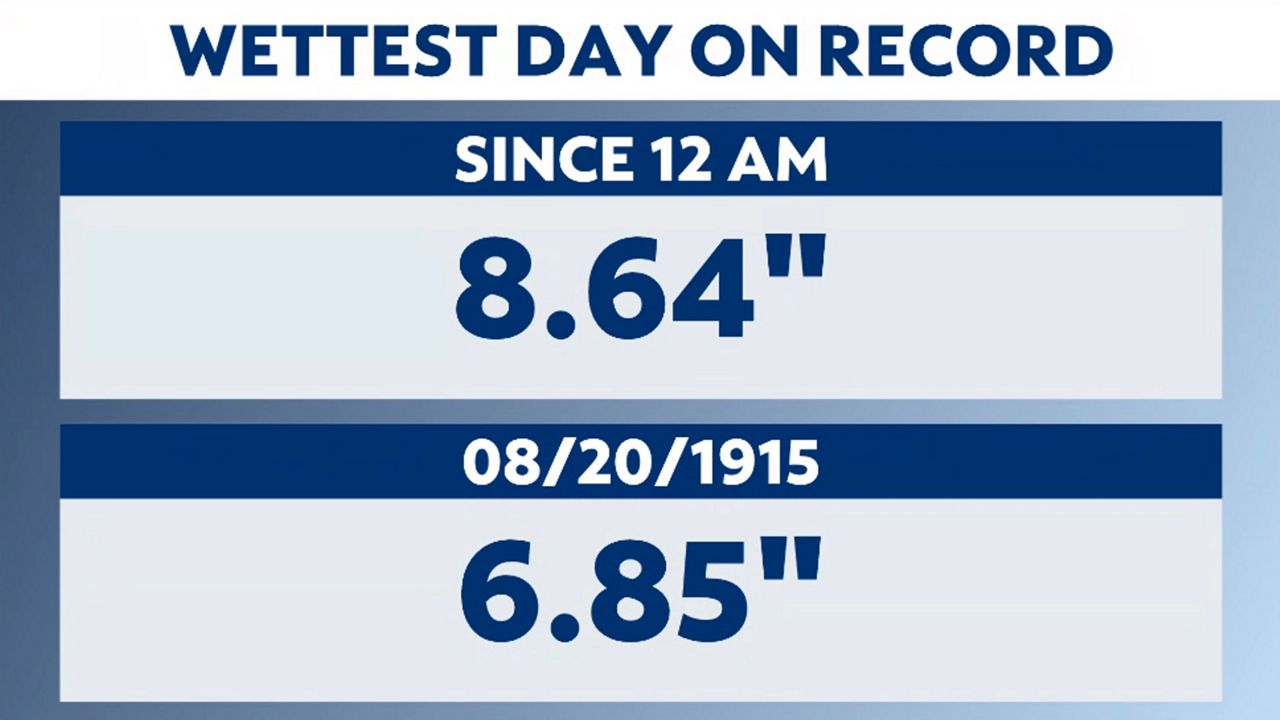
The St. Louis Lambert International Airport had their wettest day on record, observing 8.64 inches since midnight, breaking their previous all-time daily rainfall record of 6.85 inches set back on Aug. 20, 1915.
The airport shattered the old record by 7:00 a.m., thanks to torrential rain overnight. To put this into perspective on just how much rain fell during this one storm, the storm total of 9.07 inches is more rain than we typically see during both the months of July and August combined.
The reason for the extreme rain event had to do with the setup of a front. This front moved through the region Sunday afternoon and then stalled to our south on Monday, bringing some much-needed relief from the weekend’s oppressive heat.
Monday night, the front was located just south of I-70 in the St. Louis area, with a disturbance forecasted to move along it. Weather models picked up on higher amounts of rainfall, exhibiting a 3 to 5-inch swath, but had the bulk of it north of the St. Louis region.
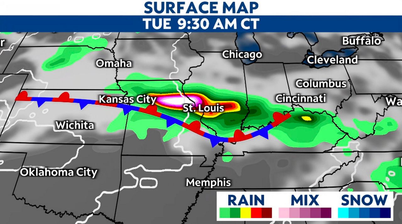
The National Weather Service issued Flood Watches for St. Louis and St. Charles Counties Monday evening. The late-day models had shifted the heaviest precipitation slightly south, brushing the northern part of the metro.
Going to bed Monday night, the chance for thunderstorms was there. Even a strong to severe storm wasn’t out of the question.
The first boom of thunder occurred around midnight, and the storms continued throughout the night, with the heaviest rain between 4:00 a.m. to 8:00 a.m. over the metro. With saturated soils, wet branches and winds gusting over 25 mph, thousands lost power before sunrise.
These storms began "training." The term "training" means that each time a storm moves east, another storm forms in its place, back-building and giving the illusion the storms are stationary or moving over train tracks. This setup results in heavy rain in a short amount of time, causing flash flooding.
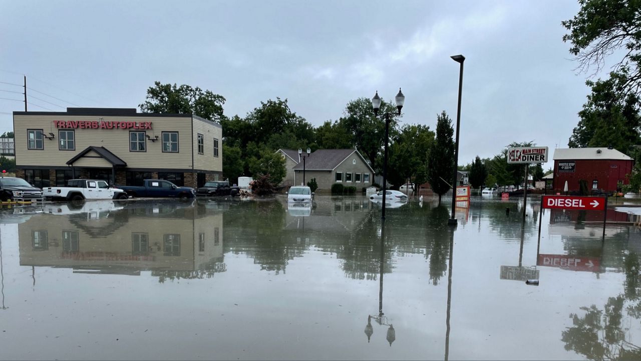
Flooded Interstates and major roadways led to stalled vehicles in both St. Charles and St. Louis counties. With evacuations and water rescues occurring all over the metro, this became a life and death situation.
I talked with evacuated residents from flooded homes about flooding like this. Most mentioned they hadn’t seen flooding like this since the 1993 flooding, but that situation was an entirely different setup.
It was a synoptic scale weather event that resulted in too much rain and snow during the fall and winter months and then a warmer spring, resulting in high water along the Missouri and Mississippi Rivers.
A much smaller-scale weather event, Tuesday’s flooding directly resulted from too much rain in a short amount of time.
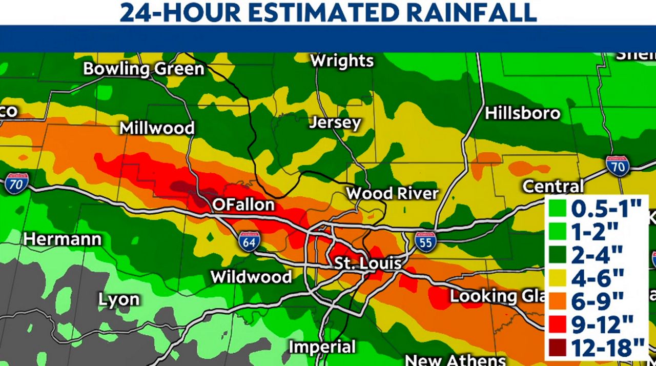
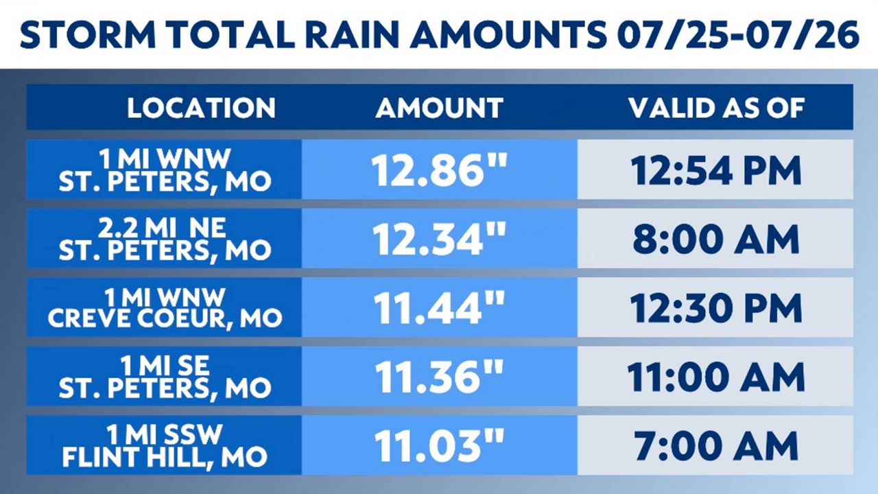
Storm total radar estimates ranged from around an inch in Imperial, Mo. to over 12 inches in Wentzville, Mo.
Rainfall reports sent to the National Weather Service in St. Louis, Mo. were more specific, with St. Peters, Mo. receiving 12.86 inches over a 12-hour span to Hazelwood, Mo. accumulating just over 7 inches by 7:00 a.m.
Downtown, where several water rescues took place, rain ranged from 9 to 12 inches. The heaviest rain moved out by midday, with it tapering to sprinkles by late afternoon.
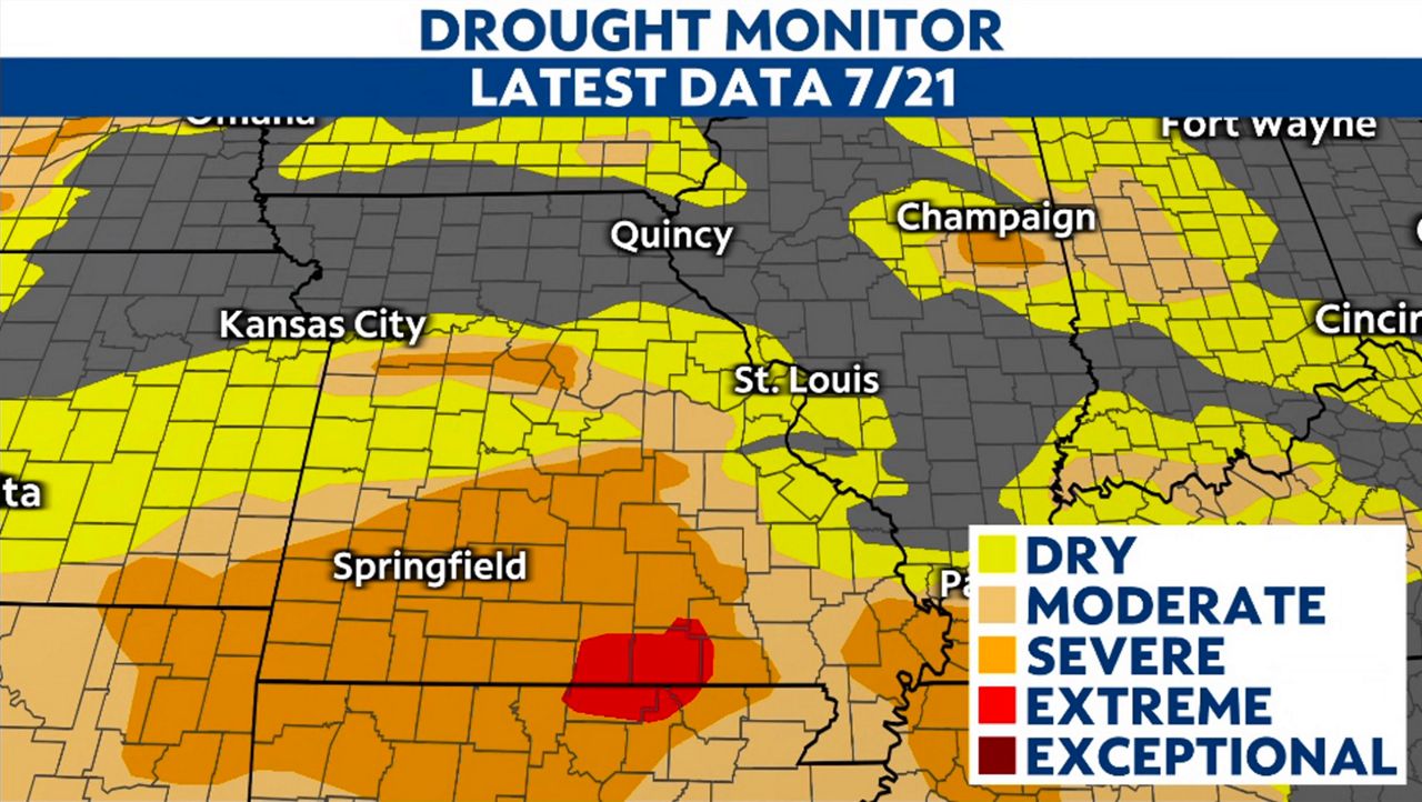
We have wiped away and replaced the rainfall deficit for the month and even the year with a surplus. It will probably erase the abnormally dry level D0 drought ranking with the latest drought monitor, which will be released later this week.
While the event this Tuesday morning may have been a once-in-a-lifetime occurrence, this doesn’t mean rain chances are done. The stalled front looks to waver over the region through the rest of the workweek, resulting in more rain and storm possibilities.
The potential for extreme flash flooding doesn’t look likely, but some minor flooding is possible as creeks and streams stay above flood stage and may be slow to recede.