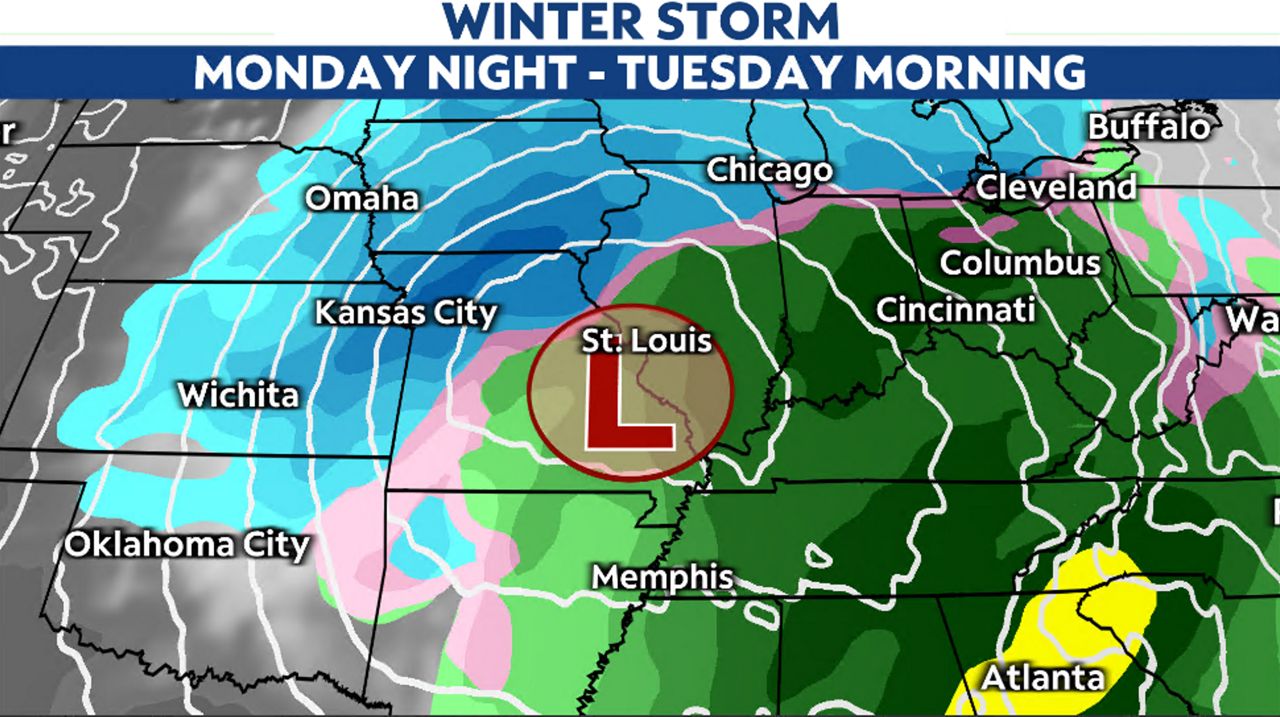
A large winter storm will traverse the country and will bring impactful weather to the state of Missouri early this week.
After the storm system dives south into the Four Corners region of the country, it will move east, picking up moisture from the Gulf of Mexico. The timing for this storm looks to arrive in the Show-Me State by Monday morning and linger into the early hours of Wednesday.
A Winter Storm Warning is in effect for Kansas City through Tuesday night.
Forecasting snow is not an easy feat, as it partially depends on temperatures. It can snow when temperatures are above freezing, as we have seen, but for accumulating snows, temperatures need to be colder.
As this system approaches from the south, it will initially draw in warmer air. High temperatures on Monday will be anywhere from the upper 30s in northwestern Missouri to the mid-40s for the St. Louis region.
This means at the onset of this storm, precipitation will be rain. As temperatures drop after the rain begins, rain will mix with some wet snow before changing to all snow in the northwestern part of the state by Monday evening.
St. Louis area will see that initial mix of precipitation, but with warmer air nudging in, the mix will change back over to rain by Monday night. Rain is expected through midday Tuesday in this part of the state.
As colder air wraps into the system during the day on Tuesday, rain will mix with and finally change over to snow in the St. Louis area. This will occur as the storm system pulls away from the region.
As for snowfall totals, this does not look to be a big snow event in St. Louis. A dry slot is likely to develop and could keep snow rates light. Accumulations look to be minor, if any, at this time.
The biggest snows in the Kansas City and St. Louis areas happen when a low pressure system tracks along Interstate 44. However, if the storm tracks just 50 miles north or south, this changes how much snow falls.
As of the latest data, the track takes it farther north, keeping St. Louis in the warmer part of the storm for longer. Kansas City, however, will see colder air arrive much sooner and could pick up a few inches of snow.
This is a large storm system that has considerable wind associated with it. Wind gusts will ramp up and could exceed 35 mph during the day on Tuesday.
Gusty winds will blow any falling or even fallen snow around, making traveling more difficult.
The entire state saw not much snow in 2023. In fact, St. Louis only recorded 3.0 inches for the whole year.
While the potential is there for a big storm, warm temperatures at the onset, combined with marginal temperatures during the event and an uncertain timeframe for a changeover, could affect totals.
While 2023 wasn’t active in snow systems, 2024 may change that. The Climate Prediction Center shows well below average temperatures for the 8 to 14 day outlook.

Forecast models are showing another winter system arriving in the region late this week, as well as much colder air.
Could this be the year snow finally returns to Missouri? Regardless, any precipitation is beneficial as 2023 ended the year with over 8 inches in deficit. Drought conditions are back in the moderate and severe category, so we’ll take all types of precipitation.
Our team of meteorologists dives deep into the science of weather and breaks down timely weather data and information. To view more weather and climate stories, check out our weather blogs section.