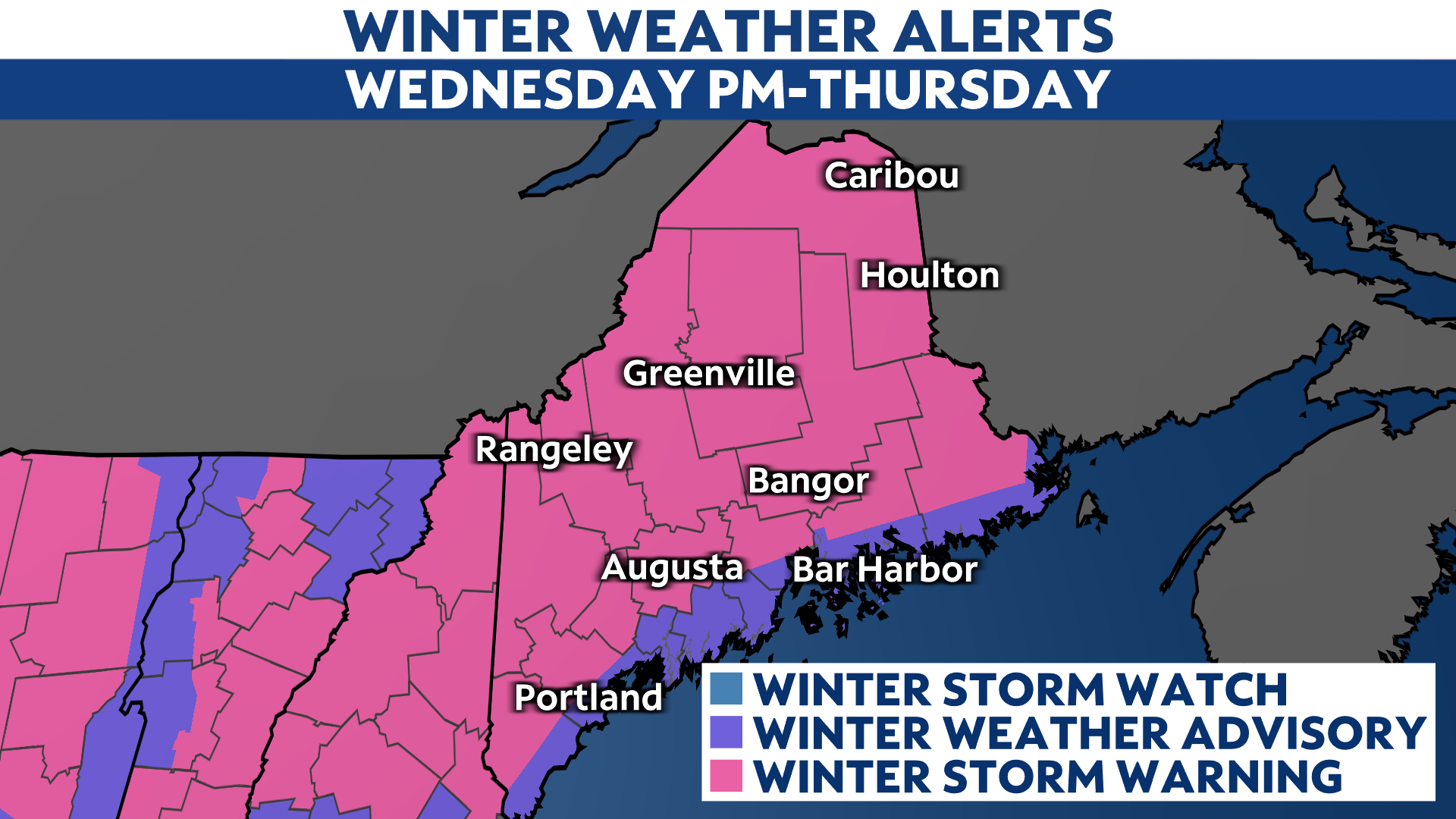
An active weather pattern will persist through this week, as New England braces for yet another, more significant winter storm set to affect Maine later on today into Thursday.
Just as parts of Maine finish shoveling out from Monday’s winter storm, another one will arrive Wednesday afternoon. While the southern part of the state felt the brunt of the first storm, all of Maine will feel the effects from this second storm.
As a result, the entire state is under a winter storm warning or a winter weather advisory beginning this afternoon through Thursday evening.

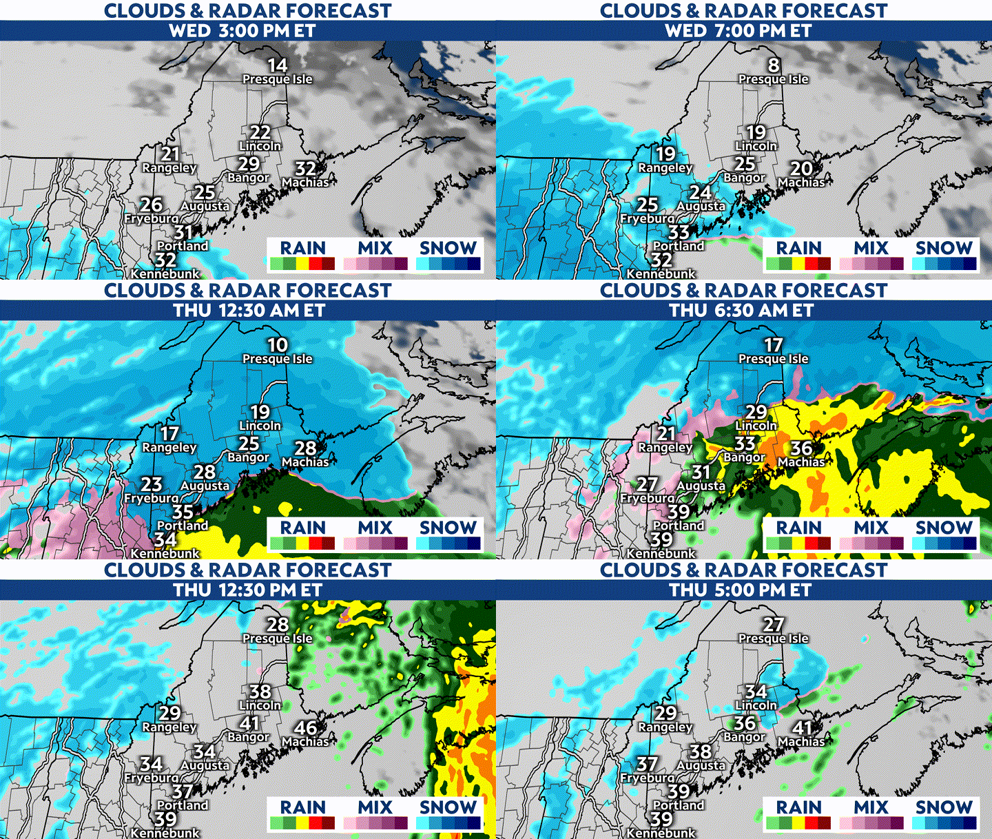
Snow will move in from the southwest late Wednesday afternoon, moving into the entire state by around midnight. At the onset, snow will be light, but will become steadier and heavier overnight into Thursday morning.
With a good portion of the state expected to wind up on the warmer side of the storm, temperatures will steadily rise overnight into Thursday, causing snow to change over to a wintry mix and rain from south to north.
As the core of the storm tracks over the state Thursday morning, all but extreme northern Maine will see this transition to a wintry mix and/or rain occur before the bulk of the precipitation moves out.

Meanwhile, the colder areas across northern Maine will continue to see mostly snow through the duration of this storm, awarding this part of the state with the highest accumulations.
Precipitation aside, this storm will also generate powerful winds, particularly as the center of the low passes over the state. Wind gusts could reach between 30 to 40 mph, and peak as high as 45 mph along the immediate coastline and the higher elevations.
The strongest winds will affect areas Downeast, where gusts could reach up to 60 mph early Thursday morning through the midday hours. Given this potential, the area is under a High Wind Warning.
Slight differences aside, most model guidance seems in agreement regarding the storm’s track and timing, tracing the center of the low near or along the I-95 corridor on Thursday morning.
Provided this holds true, temperatures will rise near and above freezing for most of Maine as milder air wraps in from the south, prompting snow to change over to a wintry mix and/or rain. Because of this, nailing down precise snow accumulations remains a challenge.
Given this, snow accumulations could add up anywhere between a few slushy inches to a half-foot for areas between the coast and the I-95 corridor. Totals will increase moving farther inland, but will remain questionable as well due to mixing.
With that in mind, it's also worth mentioning that a good portion of the state can expect to see additional sleet and ice accumulations.
While the immediate coastline will see the least amount of wintry accumulations, the highest amounts will likely approach a foot far north and west. Some of the higher terrain areas near the New Hampshire border and across the Crown of Maine could see totals exceed a foot.
Times of heavy snow, rain and a wintry mix of both will lead to hazardous travel conditions beginning later today through Thursday. While snow and ice accumulations will make roads slippery alone, snow falling at a rate of 1 to 2 inches per hour will reduce visibility significantly.
In addition, gusty winds combined with heavy, wet snow piling up on surfaces could take down tree limbs and power lines- all of which could lead to widespread power outages.
No matter where you live in Maine, this winter storm will come with significant impacts, which will affect the entire state. Our meteorologists will continue to keep you informed of the latest updates and information.
Our team of meteorologists dives deep into the science of weather and breaks down timely weather data and information. To view more weather and climate stories, check out our weather blogs section.


