
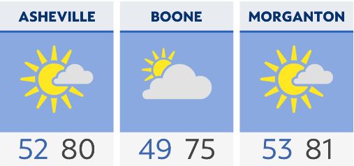
The warming trend that has started will continue with highs Tuesday warming into the low 80s in the foothills, and into the mid-70s in the high country. A quick-lived stray shower can't be ruled out tomorrow, but the rain chance stays less than 10% for the region.
Ahead of an approaching cold front will be an influx of moisture leading to a better chance for daily showers and storms starting Wednesday. The cold front moves through late Friday with the higher rainfall totals throughout the second half of the workweek confined to the mountains.
In the wake of the cold front, it'll be a pleasant weekend filled with sunshine and slightly cooler temperatures.
Check radar and the latest 7-day forecast | Share your weather photos