December is now officially here and it has many winter weather lovers asking about our chances to see a snowy winter in North Carolina. To attempt to answer those questions, we first should start with the large scale weather pattern around the globe.
One of factors determining the type of winter we will see is La Niña - the opposite of El Niño. That is a phenomenon that can drive weather patterns all around the globe. We find evidence of a weak La Niña this year through cooler than average water temperatures near the equator in the Pacific Ocean.
Here in the United States, La Niña typically keeps the jet stream north of us for much of winter. That would result less rain chances and typically warmer than normal temperatures.
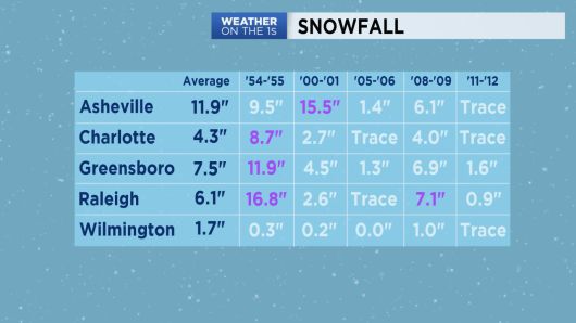
To dive a little deeper into the outlook though, we can examine similar winters to what is expected this year - the weak La Niña and a couple other weather patterns. Thanks to research from the National Weather Service in Wilmington and the State Climate Office, we identified several analog winters to this one: 1954-1955, 2000-2001, 2005-2006, 2008-2009, and 2011-2012.
Here's what we found for average temperature, rainfall, and snow those years:
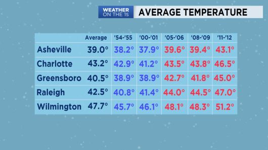
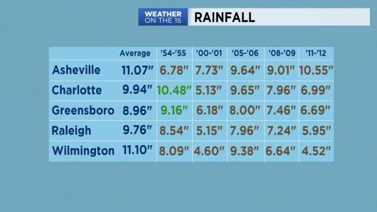
As you can see, not every winter identified as an analog to the winter of 2017-2018 actually ended up drier and warmer than average. Those are just the conditions that are most likely to take place this winter.
Remember that even in a warmer than average winter, blasts of frigid Arctic air are certainly still possible. The State Climate Office reminds us of that as they also identified the winter of 1984-1985 as an analog to this winter. In January 1985, North Carolina experienced some of the coldest temperatures ever recorded in the state. Temperatures fell below 0 in many locations. Raleigh recorded a low of -9. Greensboro dropped to -8 and Charlotte to -5. The coldest location in the state was Grandfather Mountain at -32. Despite those frigid temperatures, the winter still ended up warmer than average.
We should also note for snow lovers, the news here is not all that bad. A warmer than drier winter would suggest a lower chance for snow. However, snow has fallen in similar winters.
In reality, the science of meteorology just cannot accurately predict exactly how much snow may fall in any given winter for any specific location. Here in North Carolina, a snow forecast can be complicated by many issues. An accurate snowfall forecast typically cannot be made in this part of the country much more than three days in advance.
On a more concerning note for the winter, we are more confident about the drier part of the outlook. The season is starting with a moderate drought in central North Carolina and abnormally dry conditions in eastern portions of the state. These conditions may only worsen over the coming months. A drought in winter is typically not a big concern for agricultural interests since it is not growing season. However, water levels could drop and the drought could be an issue as growing season begins again in the spring.
Read more about the winter outlook for North Carolina:
)