


ORLANDO, Florida — The latest path for Hurricane Irma, a Category 4 storm, shifted west Friday morning as Florida continued to prepare for a major hurricane to landfall over the weekend.
- Hurricane Irma is a Category 4 storm with 150 mph winds
- The entire Florida peninsula remains in cone of uncertainty
- Landfall expected Sunday morning somewhere in South Florida
Tropical storm conditions are expected to arrive in South Florida on Saturday night, so the window to prepare is getting shorter.
Florida Gov. Rick Scott on Thursday night ordered all public K-12 schools, state colleges, state universities and state offices to be closed at least through Monday.
Dozens of evacuation orders have forced main highways to become congested. The Florida Highway Patrol has been escorting fuel trucks into the state so that gas stations can get more gas.
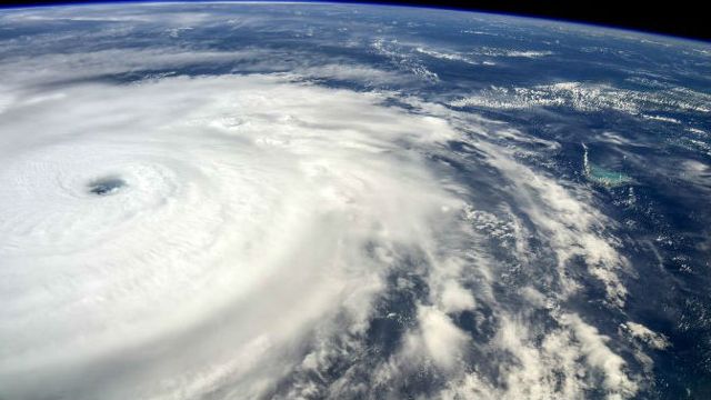
The Latest Advisory on Hurricane Irma
There are several watches and warnings in place across Florida.
At 2 p.m. ET, the distinct eye of Hurricane Irma was located near latitude 22.0 north and longitude 76.0 west. Irma has been moving toward the west near 14 mph, but the hurricane should resume a west-northwest motion later today. A turn toward the northwest is expected by late Saturday.
On the forecast track, the eye of Irma should continue to move near the north coast of Cuba and the central Bahamas for the rest of today and Saturday, and be near the Florida Keys and southern Florida peninsula Sunday morning.
Maximum sustained winds are near 155 mph, with higher gusts. Irma is a Category 4 storm. Some fluctuations in intensity are likely during the next day or two, but Irma is forecast to remain a powerful Category 4 storm as it approaches Florida.
Hurricane-force winds extend outward up to 70 miles from the center, and tropical-storm-force winds extend outward up to 185 miles.
The Hurricane Warning for the Turks and Caicos Islands has been discontinued.
Here’s a summary of watches and warnings in effect:
Storm surge warning:
- Sebastian Inlet southward around the Florida peninsula to Venice
- Florida Keys
Storm surge watch:
- North of Sebastian Inlet to Ponce Inlet
Hurricane warning:
- Jupiter Inlet southward around the Florida peninsula to Bonita Beach
- Florida Keys
- Lake Okeechobee
- Florida Bay
- Southeastern Bahamas
- Cuban provinces of Camaguey, Ciego de Avila, Sancti Spiritus and Villa Clara
- Central Bahamas
- Norhwestern Bahamas
Hurricane watch:
- North of Jupiter Inlet to the Flagler/Volusia county line
- North of Bonita Beach to Anclote River
- Cuban provinces of Guantanamo, Holguin, Las Tunas and Matanzas
Tropical storm warning:
- Cuban provinces of Guantanamo, Holguin and Las Tunas
Irma will be traveling over very warm waters, which will be a favorable environment for sustaining its strength as a Category 4 hurricane on Friday. It is projected to undergo some fluctuations in intensity with eyewall replacement cycles, but it should be a Category 4 at landfall before weakening as it lifts north toward Central Florida, where it will become a Category 1 or 2 storm.
Four to 8 inches of rain or greater is possible within the path of Irma, with localized amounts of 12 inches. By Saturday evening, Irma would be entering the Florida Straits and South Florida with bands of rain and wind.