


)
It has been an active spring in the Show-Me state, specifically, in the southwestern and southeastern parts, with numerous days of severe weather. There have been damaging winds, hail and even tornadoes reported in these regions.
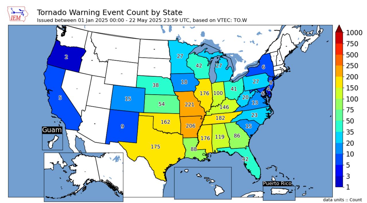
With so many severe weather events, it’s not surprising that Missouri is a leader in tornado warnings.
Tornado warnings are issued by the National Weather Service when a storm shows rotation on the radar or when a tornado is visible on the ground and has been confirmed.
Missouri leads the country in tornado warnings through May 21, with 221 warnings issued by local National Weather Service offices. It’s important to note that tornado warnings do not equate to confirmed tornadoes.
Arkansas comes in a close second with 206 warnings issued so far this year.
A tornado can be described as a violently rotating column of air that extends from the cloud base of a thunderstorm to the ground. Wind speeds in tornadoes can reach up to 300 mph and they can travel hundreds of miles.
Tornadoes are rated on the Enhanced Fujita Scale. A damage-based scale estimates the wind speeds of a tornado based on the damage it creates. The scale goes from EF0 (weakest tornado) up to EF5 (the strongest tornado).
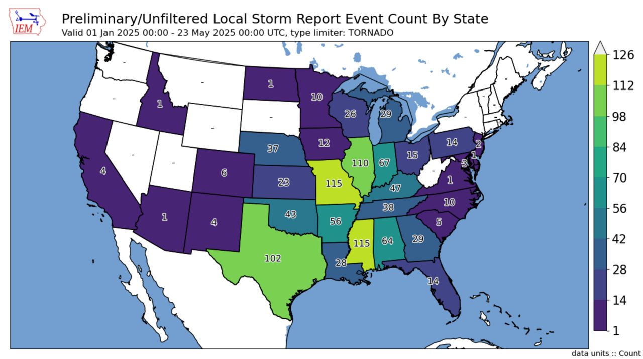
115 tornadoes have been reported across the entire state through this time frame, tying the number of twisters with the state of Mississippi.
Missouri State Climatologist Zack Leasor says that a tornado can occur every month of the year, but there is an increase in activity during certain months. “April and May account for around 40% of total tornadoes in the state.”
Preliminary tornado reports are not the same as actual tornadoes.
“In real time, the National Weather Service collects what are called preliminary local storm reports. For tornadoes, these can be thought of as eyewitness reports of the tornado,” explains Matthew Elliot, warning coordination meteorologist at the Storm Prediction Center.
However, Elliot mentioned that sometimes there may be multiple reports of the same tornado, especially longer-track ones, leading to overestimated tornado counts.
“Some preliminary reports end up not being tornadic after a ground survey has been completed while others are surveyed and entered into the official database, but never have a preliminary local storm report issued,” he said, noting that’s rare, but it happens.
Missouri is no stranger to tornadoes. The “Show-Me” state has recorded over 2500 tornadoes since 1950, says Jared Maples, a Meteorologist with the National Weather Service in St. Louis.
Adding, “The St. Louis area sees on the order of 12 to 14 tornadoes per year.”
However, he emphasizes that this is just the average since 1950. Some years have observed six times the average.
“Two years that stood out in the data were 2006, the most active with 75 tornadoes, and 2011 with 47 tornadoes.”
So far this year, through May 21, the St. Louis forecasting area has confirmed 40 tornadoes, nearly three times the annual average. It’s not uncommon to have big tornado numbers with lower intensity tornadoes. However, this year we observed the higher intensity tornadoes, from four EF3 and ten EF2 tornadoes.
May 16, 2025 tornado that went through the Central West End and north St. Louis City was rated an EF3 and, unfortunately, caused five fatalities. It tracked on the ground for 22.6 miles crossing into Illinois and was, at one point, one mile wide.
Tornado counts usually peak from March to June and then taper into the summer. The reason is because of the jet stream.
“One of the ingredients needed for thunderstorms to produce tornadoes is strong wind shear, and this is in part provided by the jet stream,” Meteorologist Alex Elmore, with the St. Louis National Weather Service, says.
“During the summer, the jet stream shifts northward toward the U.S.-Canadian border, reducing the amount of wind shear we see locally during severe weather, which reduces the chance for tornadoes.”
We may see more thunderstorms during the summer, but without wind shear, storms that become severe are more likely to produce hail and damaging winds.
Download the Spectrum News App for the latest forecast updates.
Our team of meteorologists dives deep into the science of weather and breaks down timely weather data and information. To view more weather and climate stories, check out our weather blogs section.