
ORLANDO, Fla. — Florence remains a tropical storm with the center located 15 miles west-northwest of Myrtle Beach, South Carolina and 45 miles southeast of Florence, South Carolina.
Florence made landfall this morning around 7:15 a.m. near Wrightsville Beach.
- JUMP TO: Florence | Isaac | Helene | Joyce | Elsewhere▼
- WATCH WEATHER CAMS: View live conditions up and down East Coast
- TRACKING THE TROPICS: Watches, warnings, forecasts, spaghetti models
- STORM SEASON 2018: Interactive Storm Tracker, storm supply checklist, FAQs
Florence

This will be a long duration event of flooding rain, storm surge and very strong winds over a widespread area. Already rainfall amounts of 8 to 10 inches or more have been estimated by radar.
A Flash Flood Emergency was issued for portions of eastern North Carolina Friday with already some locations exceeding a foot of rain.
Florence contains maximum sustained winds of 65 mph. Slight weakening of top winds will continue this overnight as it sits over land, but a lot of rain continues to fall.
Florence is moving slowly forward, to the west-southwest at 5mph. Tropical Storm force winds extend outward up to 175 miles. The minimum central pressure is 980 mb.
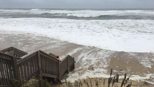
Swells generated by Florence have been impacting the southeastern US, including Florida, and will continue to do so into the weekend. While wave heights will start to drop, a high risk of rip currents will prevail.

The following watches and warnings have been posted:
A storm surge warning is in effect for:
- Myrtle Beach South Carolina to Ocracoke Inlet North Carolina
- Pamlico Sound, including the Neuse and Pamlico Rivers
A tropical storm warning is in effect for:
- Edisto Beach South Carolina to Ocracoke Inlet North Carolina
- Pamlico Soun

As the storm continues inland, Florence is projected slowly track west-southwest across the Carolinas, where it will pose a significant flood threat due to the incredible amount of rainfall forecasted.
Some areas could exceed 30 to 40 inches of rain from the storm.
Isaac

Elsewhere in the tropics, Isaac was downgraded to a depression Friday morning, but has now strengthened back to a tropical storm in the eastern Caribbean Sea. Maximum sustained winds are down to 40 mph.
The latest forecast shows weakening again as it moves west over open water. The long-term forecast remains uncertain for Isaac as it continues to encounter unfavorable tropical conditions.
All tropical storm watches and warnings have been discontinued for the Lesser Antilles.
Helene

Helene remains a tropical storm, roughly 520 miles west-southwest of the Azores. This storm will not threaten the United States, but a Tropical Storm Warning continues for all of the Azores islands.
Helene will impact these islands with rain and wind from late Saturday into Sunday.
Joyce

Tropical Storm Joyce remains out to sea in the north central Atlantic, 1040 miles west-southwest of the Azores.
With winds of 50 mph, this storm will stay over open waters and will become post-tropical by early next week.
Elsewhere
Finally, the disorganized area of low pressure over the western Gulf of Mexico has a low likelihood of development, but will still bring rain to parts of south Texas this weekend.
There’s also a small area of potential development near Bermuda, running a low chance of gaining tropical characteristics.
The next name on the list is Kirk. Hurricane season runs through Nov. 30.
The Atlantic hurricane season runs through Nov. 30.