


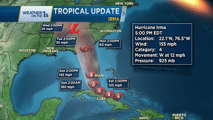
RALEIGH -- Hurricane Irma is still a monster storm that could be devastating to much of Florida this weekend. Irma weakened slightly early Friday morning from a category 5 to a category 4 storm. The latest forecast for Irma has it maintaining this intensity as it approaches southern Florida and brings the eye inland over the southern tip of Florida near dawn Saturday morning. That could bring the strongest winds in the storm over the Miami metro area during that time.
This huge hurricane is then forecast to move up the entire length of Florida peninsula Sunday. It should slowly weaken as it interacts with land. Many computer models show the storm turning to the west early next week which should bring its remnants close to Atlanta, Georgia, and even Nashville, Tennessee.
The latest forecast from the National Hurricane Center lessens the impact of the storm for much of North Carolina. Irma is still large enough to bring rain and gusty winds to the state Monday and Tuesday. Based on the latest forecast track, central and eastern North Carolina should see one to four inches of rain and wind gusts between 20 and 40 mph. Higher rainfall amounts are possible in western North Carolina where three to six inches of rain will be possible. The storm could also produce isolated tornadoes in the Carolinas early next week.
If the forecast track changes slightly to the east, weather conditions could be worse in central and eastern North Carolina. Everyone should continue to monitor the storm through the weekend for any changes to the forecast.
Spectrum News will continue to provide the most local updates on the storm with our Weather on the 1s forecasts available every 10 minutes around the clock.