


A potent coastal storm will continue to move farther north today, bringing multiple hazards across New England Tuesday through the middle of the week.
A large and powerful storm system that developed off the Carolina coast on Monday will continue to track up the East Seaboard, where it will rapidly intensify and likely undergo bombogenesis as it approaches southern New England.
A few flakes or sprinkles began to move in from the south and west late Monday night, but the bulk of the precipitation associated with this storm has still yet to arrive. Conditions will deteriorate on Tuesday leading into Tuesday night as the storm draws near to the region.
Steadier and heavier snow will spread from the south and west to the north and east by Tuesday afternoon and evening, with the heaviest bands pushing onshore, mainly south and east of the I-95 corridor.
Even though many places will start the day off above-freezing, temperatures will steadily slide downward near freezing by the afternoon. Because of this, some places could see some rain mixing in, especially for places near and along the immediate coast.
Yet, much of Maine will see predominantly snow throughout the entirety of this event.
Snowfall rates reaching 1 to 2 inches per hour will lead to quick accumulations, which will make roads slippery. Yet, strong winds factored in with this will also significantly reduce visibility, contributing to travel troubles.
Thus, the entire state remains under a Winter Storm Warning or Winter Weather Advisory through Wednesday morning.
Meanwhile, much of northern Maine will stay dry through the better part of the day on Tuesday before seeing their first flakes arrive. Given that this part of the state will be the farthest from the core of the storm, it will see the least amount of impacts. Snow will be less intense here, as well as the winds.
A few lingering showers aside, much of the state will see snow wrap up on Wednesday as this storm begins to exit the region.
Despite better chances for some mixing, we still expect the highest accumulations across the higher terrain areas in southwestern Maine. Snowfall totals here could add up between 8 to 12 inches, with the potential for locally higher amounts measuring over a foot in some places.
Accumulations will decrease moving farther north, where parts of Aroostook County may only see 2 to 4 inches at most.
Amounts aside, plowable snow and gusty winds throughout the state will be enough to cause major disruptions to travel through midweek. Those not authorized to be out on the roads should refrain from doing so to ensure they stay safe.
You can send us your snow photos here.
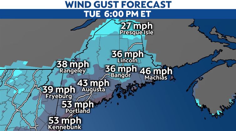
In addition, winds will also begin to rev up as the core of the storm deepens and moves closer to the region Tuesday night into Wednesday. While gusts will reach between 30 to 40 mph across the interior, areas near and along the coast could see the strongest winds exceed 50 mph.
Regardless, winds whipping through the region could damage property, in addition to bringing down trees and power lines, which could lead to numerous power outages.
Along with the wintry precipitation and winds, this system will also bring coastal impacts.
Strong onshore flow combined with large swells will increase the risk for minor to moderate coastal flooding and splash-over, especially during times of high tide through Wednesday morning.
As a result, Coastal Flood Advisories remain in effect along Maine's southern coast.
With that, this storm will also generate rough surf and large-breaking waves, leading to beach erosion in some places.
Our meteorologists will continue to keep a close eye on the development of this storm and keep you posted with the latest updates and information.
Our team of meteorologists dives deep into the science of weather and breaks down timely weather data and information. To view more weather and climate stories, check out our weather blogs section.