


What a bright and beautiful weekend! The combo of mostly sunny skies and afternoon highs in the low to mid 70s should not be missed. We sincerely hope you're spending some quality time outdoors while the weather is mild as another chilly blast will sweep through just in time to start out our first week of December, with rain heading our way by the end of the week.
Current Conditions | Radar | Travel Maps | 7 Day Forecast | Allergy
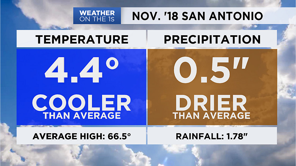
We've experienced plenty of cold weather over the past month, as noted in the November weather summary graphic headlining this blog post. Looking back at the meteorological fall season, this was San Antonio's wettest on record (25.11") and 15th coolest (avg high 68.6).
Get ready to grab your jackets again as temps head into the low and mid 40s for sunrise on Monday, and that polar front will arrive shortly thereafter. Our latest models show it bringing breezy north winds into the Alamo City by mid-morning. With wind gusts around 15 to 20 mph, the "feels like" temp (or wind chill factor) will make afternoon 60s feel like 50s.
Thanks to a very dry and stable atmosphere, this cold front should arrive dry in our area. Up in the Panhandle, meanwhile, a burst of snow is in the forecast through Monday morning.
Across South-Central TX, we're in for some chilly sunshine during the first half of the new week, with daytime highs only in the 50s on Tuesday and Wednesday. And our notorious cold spots -- namely protected valleys of the Hill Country -- could see a light freeze both Tuesday and Wednesday mornings. At the coldest on Wednesday, many of our SA-area suburbs will endure a brief, light freeze, so make sure any tender, tropical plants are brought indoors. You'll also want to make sure pets have a warm shelter, of course.
Southerly winds start to return by the middle of the week, bringing humidity back into the picture from the Gulf of Mexico in advance of a large Pacific disturbance. We see a chance for showers starting back up on Thursday then the combination of this disturbance plus a slow-moving cold front sends the chance for rain all the way up to 60% as it looks now for Friday. Our long-range models point to some possibly heavy rainfall, with potential accumulations around 2" to 4" locally.
It'll be a windy, wet and cold end to the week. The rain should taper as we get into the weekend yet temps will be colder than normal with 40s and 50s expected on Saturday.
We hope you'll make your travel plans accordingly and, for the very latest, check with us often on Spectrum News for our 'Weather on the 1s' updates every 10 minutes on TV and/or the live stream.
WEATHER ON THE GO: Download the Spectrum News app and watch our live stream no matter where you are!
GET WEATHER ALERTS: Sign up to receive weather text alerts from the Spectrum News Weather Team
Enjoy the weather!
--Chief Meteorologist Burton Fitzsimmons (@Burton_Spectrum)