


After another foggy and cloudy start to our day, we're finding some afternoon sun, heat and humidity. Daytime highs will be a lot like yesterday in the upper 80s to low 90s, but high humidity means if you're heading outside it may feel even hotter. Get ready for some big changes tomorrow! A strong cold front moves in before noon with a 30% rain/storm chance.
Temps now:

Winds are still out of the south today, bringing in extra moisture from the Gulf of Mexico, but not moving around very much. Behind our front tomorrow, winds will be much stronger out of the north, sustained from 10-20 mph for most of Sunday.
Sustained winds now:

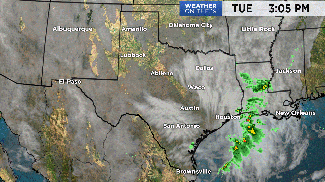
Travel looks good this afternoon state wide, but showers and thunderstorms will develop after midnight across North Texas as our cold front moves in.
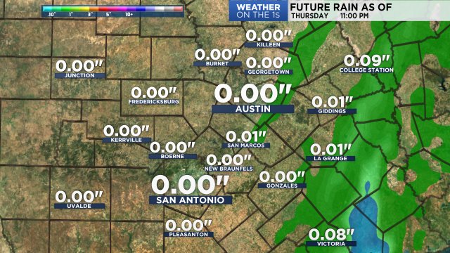
The front moves into the northern Hill Country around sunrise, then into the San Antonio metro close to 10-11 AM, moving south and quickly clearing before noon. This front looks to be more of a wind maker than rain maker, just like the front from last week. Rain totals will range from a few hundredths of an inch to a quarter of an inch. Skies will gradually clear from north to south late Sunday.
Our model shows rain totals through Monday:
Temperatures on Sunday will be much cooler in the 60s and 70s, but a gusty north wind will make it feel more like 50s and 60s for most of the day. If the clouds stick around, daytime highs may run a few degrees cooler. So if you've got outdoor plans, you need to dress for summer today and fall tomorrow, a few more layers will come in handy! Morning lows will be chilly in the 40s and 50s, and the afternoon stays comfy and below average in the 70s. A warming trend puts highs back to normal, in the low 80s, by the end of the week. Then we're tracking more moisture and our next chance for showers by Friday and Saturday.
Plan here with your 7 day forecast.
Enjoy the rest of your Saturday!
-Meteorologist Emily Borchard