


After starting on a cool note, our first day of the holiday week will feel a bit more comfortable with afternoon temps in the mid to upper 60s. We're looking for abundant sunshine, and the air will feel slightly less crisp thanks to the return of humidity. Between now and Sunday, we see at least two cold fronts coming and neither will likely put out any rainfall. Most Texas temps will run near or slightly above normal through the weekend.
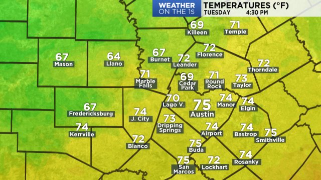
Metro Austin hit a high of 66 at 2:55 p.m. yesterday. During the night, temps dropped quickly and some made it into a light freeze by sunrise, as expected. This morning's coldest lows:
29 Fredericksburg 10 WSW
30 Bertram 8 SSW
30 Spicewood 2 NNE
31 Dripping Springs 5 SSW
31 Jonestown @ Big Sandy Crk
31 Lago Vista @ Cow Crk
31 LBJ Ranch @ Pedernales
31 Marble Falls 14 ESE
32 Burnet 1 WSW
32 Driftwood 4 SSE
32 Jollyville 2 SW
32 Leander 5 W

At this hour:
Today's forecast puts us slightly below the normal high of 70:
Look for rural/Hill Country 40s tonight:

There's little rain in the forecast across the Lone Star State this week, which means good news for Thanksgiving travel. Locally, we have about a 10% chance tomorrow as a weak cold front sweeps through the region. Ahead of it, strong southerly winds will bring in more warmth and humidity from the Gulf of Mexico. Look for wind speeds up around 15 mph with gusts near 20 mph today, and they'll get even stronger tomorrow:
Futurecast predicts the front will arrive during the afternoon tomorrow, and it'll likely do so without any rain in the picture. Our in-house model shows a few spotty showers firing up briefly along the front across East and SE TX but not locally. Winds will shift and become northerly by late afternoon, with sustained winds forecast to pick up to near 25 mph late tomorrow night. We'll look for gusts above 30 mph into early Wednesday. As a result of the front, temps will be cooler on Wednesday with a low near 50 and highs only in the mid 60s. Plan for a clear sky and cold temps on Thanksgiving morning, giving way to a bright and mild afternoon with low 70s. Thanks to high pressure slowly moving towards Texas from over Mexico, temps will rise up closer to 80 Friday and Saturday before another weak, dry cold front enters the picture. As of now, that front is timed to arrive Saturday afternoon or evening, with a slight drop in temperatures for the second half of the weekend. See the 7 Day Forecast for more. In general, for Texas, we're expecting a warmer-than-normal and drier-than-normal end to November and start to December.
Enjoy the weather!
--Chief Meteorologist Burton Fitzsimmons (@Burton_Spectrum)