


NORTH CAROLINA -- After an active day of weather Saturday to kick off the weekend, unsettled weather will continue for the next several days as plenty moisture begins to filter in from the south starting Monday. This will be coupled with slightly cooler conditions.
- Additional scattered showers and storms will move through the area today, but largely remain under severe criteria
- The additional cloud cover and showers should keep temperatures at or below average
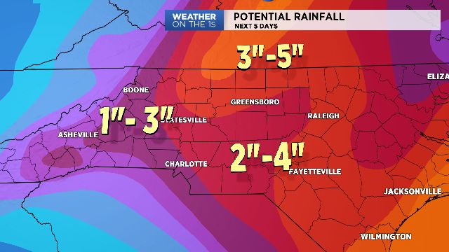
- Wet forecast where rainfall totals could range from 2" to nearly 5" through Friday for the Piedmont and Triad
The same system that brought strong to severe storms across the region Saturday will continue to impact our weather through the rest of the weekend and well into next week.
Additional scattered showers and storms will move through the area today, but largely remain under severe criteria -- unlike Saturday.
While Sunday won't be a complete washout, the additional cloud cover and showers should keep temperatures at or below average, with highs in the mid and upper 80s.
This same weather pattern will persist for the next few days as the aforementioned system drifts southward and eventually brings a fetch of deep moisture across the area from both the Gulf and Atlantic.
This will translate to an unsettled, wet forecast where rainfall totals could range from 2" to nearly 5" through Friday for the Piedmont and Triad. While storm chances will begin to wane by late in the week, we still will keep a chance of storms in the forecast at least through next weekend.
Get the latest news, sports and weather delivered straight to your inbox. Click here to sign up for email and text alerts.